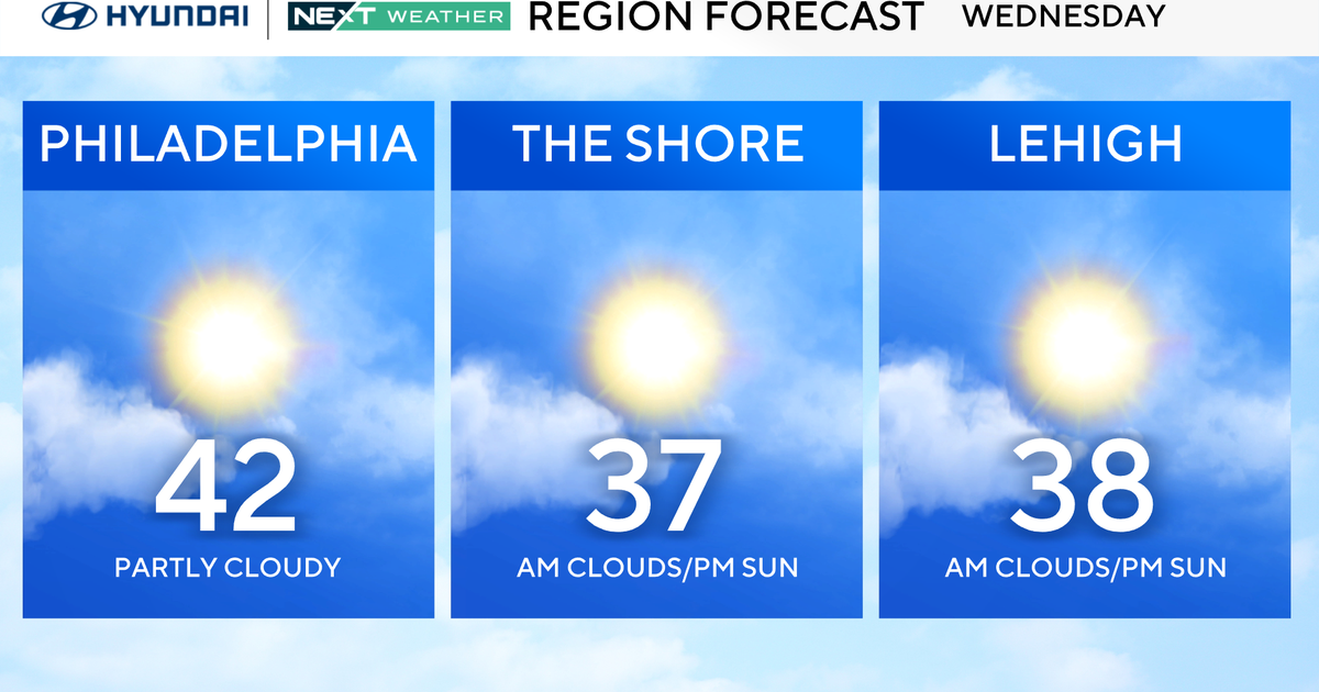
Expect Lots Of Rain Showers In The Next Week
After an extremely wet spring, which saw our drought completely wiped out, the month of July has seen a return to very dry conditions. There have only been 3 days this month with any significant rainfall and much of what has fallen has been hit or miss, with many towns missing out.
This is not abnormal for July, as most of our rainfall this month usually comes from thunderstorms, which by their nature are more scattered. The lack of rain this month has caused many lawns and gardens to suffer; brown is an increasingly popular color in many backyards. I don't think many folks are complaining though. I mean, I am sure you would trade some brown in your grass for a sunny and warm vacation week, right?
Check: Interactive Radar | Current Conditions
Well, the warm and dry weather pattern is about to change…a weak "trough" in the jet stream is setting up just to our west and will become a semi-permanent feature for the next several days. This will lead to several changes in our July weather, including a lack of significant heat and a near daily threat of pop-up or scattered showers and storms. Several "disturbances" or low pressure areas will dive into this trough to our west, and as each one does so, it will bring a threat for some wet weather. The good news is that most of these small weather systems will be weak and quick moving, so no daily washouts are likely. However, for the next 7-10 days we will have to deal with nearly a daily threat of some passing shower activity, mainly in the afternoon and evening and mainly to the north and west of Boston.
As for the immediate forecast, this weekend…
On Saturday one of those weak disturbances will be passing by, leading to a good deal of cloud cover and a risk of scattered showers and storms. The best chance for wet weather will be well to the north and west. An onshore flow will keep lots of clouds locked in and therefore limit our chances of severe thunderstorms. The air will remain fairly humid and temperatures will range from the 70s near the coast to the low 80s inland in spots with more sunshine.
The weather models disagree somewhat on our weather for Sunday. Some keep it fairly dry while others bring another weak disturbance through, leading to some moisture. At this point we are forecasting slight improvement on Sunday over Saturday, a bit more sunshine and just a small risk of a passing shower or storm, not likely anything too organized. The humidity will remain somewhat high and temperatures again will be in the 70s close to the coast and 80-85 inland away from any onshore winds.
If you are on vacation next week, we expect more of the same…modest humidity, periods of sun, clouds and scattered showers and temperatures in the 75-85 degree range, no real heat.