Hurricane Ernesto's path is east of Massachusetts, but big waves and rip currents possible along coast
BOSTON - Hurricane Ernesto has battered Puerto Rico and is now heading for Bermuda. In a few days, Massachusetts will feel some impacts from the storm on the coast.
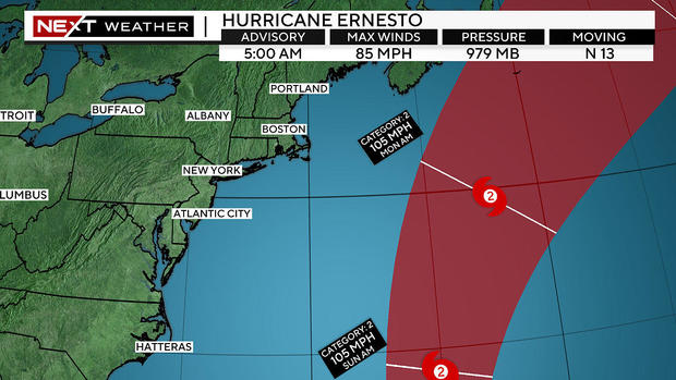
Hurricane Ernesto path
The latest National Hurricane Center forecast track continues to suggest a northward path and strengthens Ernesto to a major category 3 hurricane by Friday morning.
The center of Ernesto is forecast to make a very close pass just to the west of Bermuda early Saturday as a category 2 hurricane. If this track does indeed occur, the island could experience some of the strongest winds from Ernesto on the eastern eye wall.
The ocean water temperatures remain very warm and well above average for this time of year. Surface temperatures will be well into the 80s for Ernesto's entire journey from its current position to Bermuda, hence the projected intensification.
Ernesto will face some adverse conditions at times in the next few days, mainly from wind shear. It is projected to pass through an area of moderate shear in the 24 hours before reaching Bermuda, this is reflected in the NHC's slight downgrade from category 3 to category 2 later on Friday.
Once it passes Bermuda, Ernesto may wobble a bit back to the west, undoubtedly giving the Northeast a bit of a scare.
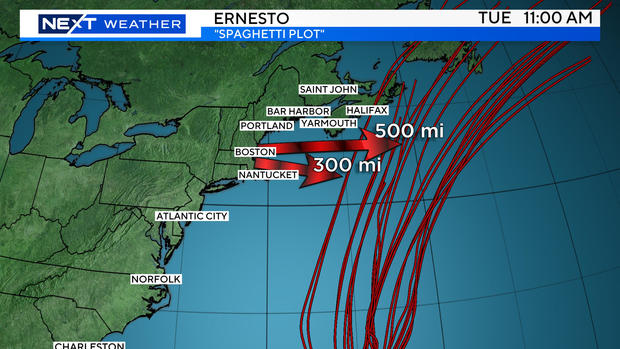
Ernesto spaghetti models
However, just about all of our models agree that Ernesto will pass at least 300 miles to our east and perhaps as much as 500-to-700 miles offshore Sunday into Monday.
At that range, we do not expect any rain or wind impacts in New England associated directly with Ernesto.
There will be some impacts at our coastline. The Atlantic is going to become very angry as Ernesto approaches and eventually passes by.
We could easily see 5-10 foot waves at many of our beaches, especially over the Islands and outer Cape Cod this weekend into early next week.
Just offshore, there could be swells of 10-20 feet.
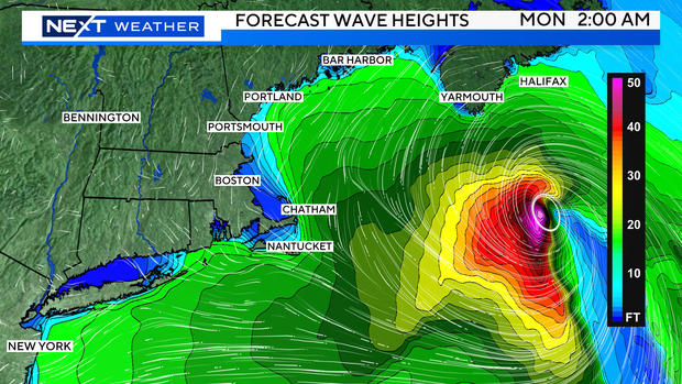
We expect there to be numerous rip current/surf warnings starting as early as Friday or Saturday and continuing for several days.
Lastly, a reminder that hurricane season is just beginning. The majority of the action is likely to lie ahead. Peak tropical activity typically comes from late August through mid-October.