Cooler Week In A Mild November..Signs of Cold For December
What a day outside! No it won't be absolutely sunny the whole time. There will be times of clouds...but today is all about the mild temperatures. Temps have quickly climbed into the 50's this morning and will be climbing into the Lwr-mid 60's by afternoon. Mixed skies this morning will give way to increasing high to mid-level clouds this afternoon and evening ahead of a cold front. Ahead of this front gusty SW winds will be strong for the Cape & islands with gusts to 30-40 mph this afternoon. Winds will diminish with the passing of the front tonight as winds shift to the north. Too much dry air down at the ground, so I am not expecting any showers...maybe a sprinkle in western New England.
As we have been talking about, this front will stall south of New England Monday across the Mid-Atlantic. overrunning clouds will ride along this boundary separating the warm air south from the cooler air which will have moved in by high pressure which will reside over southern Canada and Norther New England. Monday will be bright and sunny in VT, NH, & ME closer to the high...but these overrunning high-mid clouds will make for a greyish Monday south with cool NE winds and highs mostly in the mid 40's..nearing 50 at south coast. A few showers may skirt the south coast...but most will remain dry.
Canadian high pressure will continue to move eastward and slide towards the Canadian Maritimes..but close enough to exert subsidence and sunshine with cool onshore winds into Tuesday. High to mid level clouds will quickly be increasing later in the day ahead of our storm system which will bring rain to us as early as Tuesday night. We will be tracking a low moving through the Ohio Valley and then across Southern New England Wednesday likely to bring a chilly raw rain in the 40's with gust winds at the coast. Rain will be heavy at times with the potential for .50-1.50" rain. Wet snow may begin to mix in by evening in the NW hills.
The Low will be off the coast by Dawn Thanksgiving morning. strong northerly winds and cold advection over warmer water may help to form ocean effect snow for the Cape...maybe a few flurries at the coast...Very short lived. Skies will be clearing with increasing sun...but blusteryNortherly winds behind the departing storm will keep temps in the mid 40's with windchills in the 30's
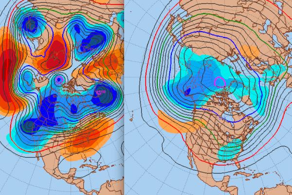
High pressure builds in to end the week with sunshine and warming temps into the weekend with developing SW winds with temps back into the 50's and Lwr 60's by Sunday. The final week of November will feature more ridging on the ast coast and an airmass dominated by the subtropical jet...but this may be all she wrote for this warming trend. Record cold is in Alaska and this will begin to push south. Ensemble forecasts are showing a shift from a ridge and mild temps this month on the east coast to a transition to a trough for the eastern half of the US which will open the door for cold to enter as well as a stormier pattern and the increased chance of more snow events. Though this November has been pleasantly mild...you know this can't stay like this forever. A change to the cold for December so very typical. You can't fight time or sun angle for that matter.
