Clipper Parade Riding South
Most of us woke up to a light coating of snow this morning. Skies have cleared across NNE, with more in the way of clouds in SNE...especially at the coast. Brighter skies will be found inland today with highs in the lwr-mid 30's with light Northerly winds...supplying the colder dry air from the north.
We are tracking a strengthening area of low pressure pulling off the mid-Atlantic, heading Northeast and will track far enough away from us tonight that we will be spared any real accumulating snow fall. Still, we will have to watch it closely. A piece of energy will be sliding off the coast tonight and merging with the low allowing this storm to deepen off the Cape tonight. There is a chance for a few bands of snow to clip SE MA and the Cape late Today and tonight. This upper level energy could provide the necessary lift to keep theses snow showers going on the Cape overnight. Any accumulations should be minimal and confined to the coast. Cape Cod & the islands would have the best chance of seeing 1-3" of snow with a coating-2" at the south shore. The way this winter has gone, I would lean on the lighter amounts.
As soon as this storm begins to lift into the maritimes it will phase with the upper level energy to become a much stronger storm and make Blizzard Conditions in parts of eastern Canada. As it backs westward, it will grab a chunk of cold arctic air and steer it from Canada and funnel it right into New England under blustery WNW winds. The colder air will be stable with plenty of sunshine Monday, but the winds will make temps in the Lwr 30's feel like teens and 20's. An arctic front will slide through Monday night and open the door for the real arctic air to slide in. A very cold start Tuesday in the single digits and teens with highs only to climb back into the 20's by afternoon with the sunshine..but lighter wind as a weak high from Canada builds over the region.
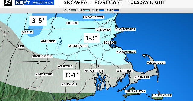
Meanwhile, with this trough in place reinforcing the cold air, little weak clippers continue to slide south of New England..staved of any real moisture or lift. Sometimes, these clippers can have explosive energy once they hit the coast and can make for some locally heavy snow. Not this time. One shortwave will scoot past monday night with a flurry or two. Another weak low passes Tuesday night and Wednesday morning which could make for another coasting of light snowfall.
High pressure will build in for Thursday which could end up being the best day of the week with highs in the 30's to near 40 with sunshine and a slightly warmer feel. The are some conflicting models for the Friday forecast. Will it be a strong coastal storm, bringing rain and snow for the north? or will it be more of a typical frontal passage with a mix of rain or snow showers. Hard to say...most resolution with the models is for the frontal passage scenario...but the Euro is showing the powerful coastal storm..so we will have to see which way the pendulum swings on that.
Overall, this next blast of cold air Monday and Tuesday would be all she wrote for the Arctic air for now. A somewhat milder trend of weather will be developing through the mid month and should take us until the about the 18th. After that, the cold air will likely return with a vengeance to end the month and should come with a more active storm track after a stretch of some benign weather for February's standards. I don't really see any big snow storms, but we could still see an active track with a few potent lows move through...but the chances for more rainy mixes will be increased for Mid-February.


