Nor'easter To Dump Heavy, Wet Snow Wednesday Evening
BOSTON (CBS) - Our second nor'easter in less than a week is on our doorstep and will make for a very challenging, messy commute Wednesday evening. This one will be vastly different from our last nor'easter.
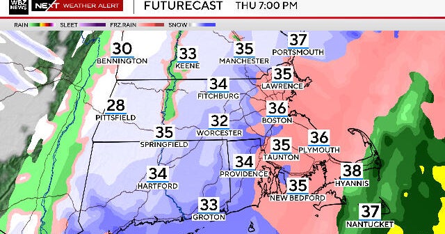
For most of southeastern Mass., yes, this will largely be wet, not white. But the farther north and west (inland) you go, the temperatures will lower just enough (close to 32 degrees) to make for a very heavy and wet snowfall.
Where is that line of demarcation? Who is cold enough for all snow vs. a mix vs. all rain?
These are questions we are still struggling over and the answers will have very large consequences and effects from town to town.
TIMING
Wednesday morning - Just some scattered flakes and drops, very little, if any, impact on the commute.
Wednesday afternoon - The steady rain and snow arrive between noon and 3 p.m. and things ramp up quickly. Where the snow is falling, likely west of I-95 and certainly west of 495, it will be high intensity stuff, 1-to-3 inches per hour at times! Meanwhile, closer to the coast and over southeast Mass., periods of heavy rain and some local street flooding will occur.
Wednesday evening/night – The heavy rain and snow will continue through about midnight with a change from rain to wet snow occurring in Boston and many coastal areas.
After midnight, the coverage of the snow will become a bit more spotty, mainly focused on areas north of the Mass Pike.
By 7 a.m. Thursday there will just be a few lighter snow showers in extreme northern Mass. and southern New Hampshire.
This will bring a sudden end to the rain and snow for Southern New England, leaving just some scattered showers thereafter. Yes, this is a very quick shot of precipitation!
SNOW
This will be a very heavy and wet snowfall.
The typical snow to liquid ratio is about 10:1, meaning 10 inches of snow for every 1 inche of liquid precipitation.
With temperatures close to or slightly above 32 degrees within the snow zone, we anticipate that ratios will be much lower, perhaps 7:1 or as low as 5:1.
The snow will also compact very quickly and easily, so if you get 12 inches it may only look like 6 or 8 inches due to the heavy weight.
0-to-1 inch: Southern Plymouth and Bristol counties, the entire South Coast and all of Cape Cod and the Islands, essentially all rain.
1-to-3 inches: Boston, northern Plymouth and Bristol counties and most of Norfolk County, also the immediate North Shore to Cape Ann.
3-to-6 inches: Just north and west of Boston to Route 128, down to Providence.
6-to-12 inches: 128 to I-495 belt from Wayland to Framingham, Holliston and Burlington and all areas north and west.
12-to-18 inches: Elevated areas including the northern Worcester Hills, Berkshires, Monadnock Region, southern Greens and Whites.
RAIN/FRESHWATER FLOODING
It has been an active, wet stretch as of late and rivers are already near their banks.
Another 1-to-2 inches of rain from this nor'easter will once again cause localized flooding of streets and urban/poor drainage areas as well as some minor rivers and streams to crest. This is of course, mainly for coastal areas and southeastern Mass. where the storm will be largely rain.
WINDS
The wind gusts, while not nearly as powerful as our last nor'easter, could still cause some additional damage and power outages.
Up to 60 mph - Cape Cod, Nantucket, Cape Ann
35-50 mph – Rest of the Coastline
25-35 mph – Inland locations
COASTAL FLOODING
Thankfully the tides are 1-2 feet lower (astronomically) than they were during the brunt of last week's storm. While there will likely be some minor coastal flooding around the early morning high tide on Thursday (between 1 a.m. and 5 a.m.), it will not come anywhere near the destruction caused last week.
The highest threat for pockets of moderate flooding is over the North Shore (coastal Essex County from Salisbury to Cape Ann).
A 2-to-3 foot storm surge in combination with seas 20-to-25 feet close to the shoreline should create some moderate flooding issues and beach erosion in those locations.
WHAT'S NEXT?
Well, things quiet down through the weekend, temperatures climb to slightly above average by Saturday and Sunday (mid 40's) and don't forget, we turn the clocks ahead one hour Sunday at 2 a.m.
BUT, our next potential storm threat comes Monday.
It's way too early to tell if this will be a hit or miss, but it does appear that another sizable coastal storm will form off the Carolinas late in the weekend. This one MAY stay too far south to hit New England, but being that it is still a week away, there really isn't much sense in speculating any more on this one.
As always, we urge that you stay tuned to updated forecasts on WBZ-TV and CBSBoston.com.
Follow Terry on Twitter @TerryWBZ
