The heat and humidity in Boston this summer is nearing record levels. Is this the new normal?
BOSTON - We are just about at the halfway point of meteorological summer (June-July-August) in Massachusetts and so far, the main story has been the excessive heat and humidity.
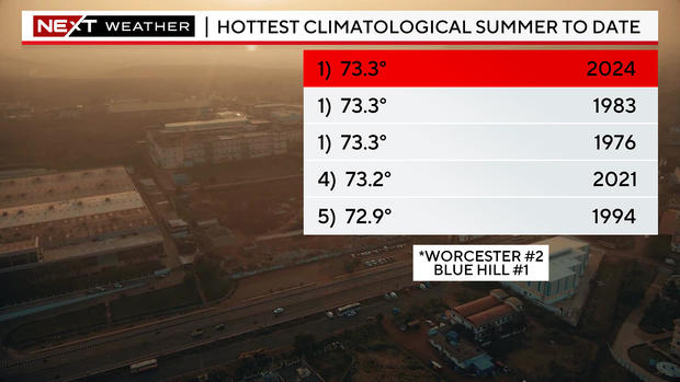
Thanks to the excessive heat in the last 10 days, Boston is now tied for the warmest summer to date. Worcester is number two and at the Blue Hill Observatory in Milton it's number one.
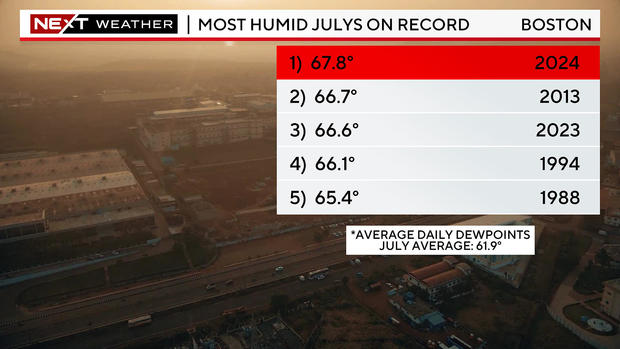
In Boston, it has been the high humidity and, in turn, the warm nights that have tipped the scales so far. This month is on pace to be the most humid July on record (July 2023 is third on the list). And, as of this writing, Boston has had nine consecutive nights with low temperatures of 70 or higher.
Is this the new normal?
This begs the question... is THIS the new normal? Are we destined for a climate more like the deep South in the summertime when it comes to humidity?
At this point, the sample size is simply too small to make that leap. In fact, July of 2022 was one of the driest Julys on record.
However, there is no denying that not only is our planet warming, but the oceans are at all-time record warm levels. This means more available moisture in the atmosphere and certainly plays a part in the humidity levels and the excessive amounts of rain that we tend to get much more frequently of late.
If you head west of Boston, away from the occasional cooling ocean breezes, the heat has been even more dramatic in the last few weeks. Boston has had four days of 90+ in July.
Just a few miles inland, towns like Bedford have hit 90 on nine of the last 11 days. Fitchburg has done it on 11 of 13 days.
When will we get cooler weather in Boston?
There is relief in sight!
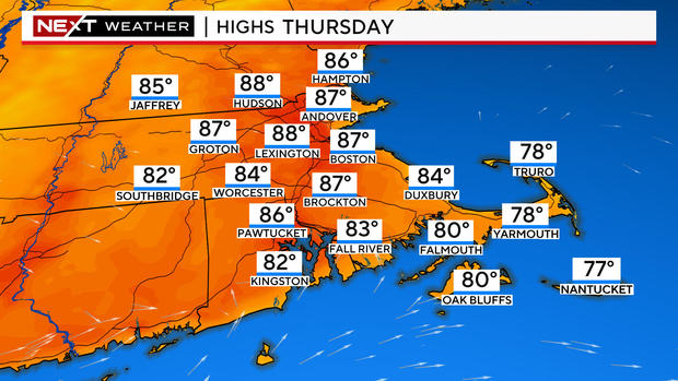
Look at the high temperature map for Thursday across central and eastern Massachusetts - there are no 90s.
In order to get there, we will have to endure one more night of thunderstorms.
The highest threat Wednesday night lies between 6 and 10 p.m. in central and eastern Massachusetts.
There may be some briefly heavy downpours and scattered, strong, straight-line wind gusts.
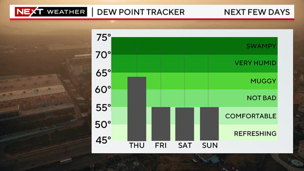
Here's when the humidity will drop in Boston
Thursday will be our transition day. There will be some lingering showers and humidity in the morning, but the skies and the air itself will be clearing and drying during the second half of the day. Dew points will plunge and be in the 50s by Friday and Saturday, a HUGE change.
The upcoming weekend looks fabulous! High temperatures will remain above average, in the mid to upper 80s, but the air will be much drier. There is only a very slight chance of a thunderstorm on Sunday, most of the area will remain dry right through Monday.