Mile-by-mile guide for the 2024 Boston Marathon
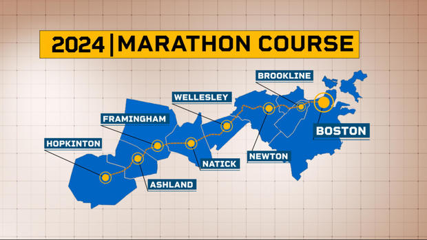
BOSTON – From the start in Hopkinton to the finish line 26.2 miles later, here is a look at what you can expect on the course for the 2024 Boston Marathon.
The Boston Marathon route is iconic, stretching from Hopkinton to Boston while bringing runners through several other communities in between.
You can follow along with WBZ-TV for updates and also find out how to track your favorite athletes. The winners have already crossed the tape.
If you aren't sure what to expect as you head out on Marathon Monday, here is a mile-by-mile guide to the course.
Where Does the Boston Marathon start?
You'll likely be experiencing a wide range of emotions as you gather in Hopkinton to get the Boston Marathon started.
When waves start taking off around 10 a.m., you and a large group of fellow runners will begin with a steep drop and a small uphill at around the 1k mark. In total, the course drops around 130 feet in the first mile. You'll be running by a big group of spectators as you get started.
Mile 1 to Mile 2
You'll head from Hopkinton toward Ashland, and the road begins to flatten a bit. The field of runners will also begin to spread out as well. There are some rolling hills in this portion of the course.
Mile 2 to Mile 3
You'll find a festive atmosphere as you find your rhythm in Ashland. There will be some more rolling hills during this stretch of two-lane blacktop, but nothing major.
Mile 3 to Mile 4
During this mile, you'll pass the Ashland Commuter Rail Station, as well as the clock tower at the intersection of Union and Chestnut streets. Make sure you don't overexert yourself as you may be tempted to do with some downhill running.
Mile 4 to Mile 5
You will now be moving from Ashland into Framingham. For the first time in the marathon, you'll be gaining elevation at about 25 feet during this mile. At the 4.8-mile mark, you reach Framingham, which is the third town out of eight total.
Mile 5 to Mile 6
Thanks to three small rolling hills, you'll decrease elevation a bit. Runners will be significantly spread out, so you will have room to run. The 6-mile marker is found on Bridge Street.
Mile 6 to Mile 7
Starting this mile, you'll be winding downhill. Careful around the 6.2-mile mark as you cross the Framingham train station, because you will be crossing the tracks. The course will flatten out, but remember to maintain your pace and don't try to speed up too much.
Mile 7 to Mile 8
You'll leave Framingham around the 7.3-mile mark, entering into Natick. You will hit a bit of an uphill, then pass the 8-mile mark in West Natick.
Mile 8 to Mile 9
A slight climb will bring you past several office buildings and businesses. There will be another minor uphill near Speen Street, but things are pretty flat.
Mile 9 to Mile 10
There won't be as many spectators during this mile. You will pass train tracks on the left and Lake Cochichuate on your right. This stretch will bring you to the 15k mark and then you'll run a slight uphill climb toward town center.
Mile 10 to Mile 11
Crowds will be getting bigger while you make your way through Natick Center. Spectators will likely greet you with high fives on your way through.
Mile 11 to Mile 12
Starting off, you'll be headed uphill. But after the first quarter of a mile, the hills will roll downhill until about the 12-mile mark.
Mile 12 to Mile 13
You should expect some sharp elevation gains as you come to the main gate of Wellesley College. But the good news is you'll get a boost from the screaming college students nearby.
After a small drop, you'll pass the 20k mark before climbing to Wellesley Center.
Mile 13 to Mile 14
More enthusiastic crowds will greet you in downtown Wellesley. Enjoy the mostly flat mile because there are tougher miles to come.
Mile 14 to Mile 15
This is a largely flat stretch that will bring you across Route 9. If you're feeling tired, it's a good time to slow down and refresh yourself because you are about a mile away from the toughest portions of the course.
Mile 15 to Mile 16
This mile begins with a small climb, but about halfway through, the road quickly goes about 100 feet downhill into Newton Lower Falls.
Mile 16 to Mile 17
Once that downhill bottoms out, there is a quick stretch of flatter ground. You'll pass the "Entering Newton" sign on your left. Almost as soon as you head into Newton, you begin a big climb that lasts for more than a half-mile. Crosswinds can be a challenge in this stretch. After you pass Newton-Wellesley Hospital, the road drops a bit and flattens near Woodland Golf Club.
Mile 17 to Mile 18
You are starting out flat here as you pass Woodland's Green Line station. At mile 17.3, you will make an iconic turn onto Commonwealth Ave. with the firehouse on your right, where large crowds will be rooting you on. A short time later there is another large elevation increase on Firehouse Hill. It's steep, but not lengthy, and you'll then drop a bit after you reach the top.
Mile 18 to Mile 19
Things start heading uphill again after the 18-mile mark, but it's not dramatic. About three-tenths of a mile in, you'll cross Chestnut Street and pass the 30k mark.
Mile 19 to Mile 20
Newton City Hall will come into view here. About one-fourth of a mile in, you'll see a hill that has two phases. There is part that is steep but short. Then it flattens and there's another short climb.
Where is the Boston Marathon's infamous "Heartbreak Hill?"
Good news! You're getting closer during this stretch from mile 20 to 21 in Newton. The bad news is you've arrived at Heartbreak Hill. It is a steep half-mile uphill stretch that will challenge you during a time when you're starting to run out of gas as you deal with elevation. You may want to shorten your strides, and keep your eye just on what's in front of you instead of looking at the top.
Mile 21 to Mile 22
With Heartbreak Hill behind you, the road starts to plummet and you're making your way through Boston College. There is a stretch of downhills that can be challenging on your tired legs, but there will be a lot of noise and cheering to help push you through.
Mile 22 to Mile 23
The road flattens or, then bottoms out for about half a mile. You'll make your way into Cleveland Circle, and should once again be careful of Green Line trolley tracks. With the final quarter-mile climb, you will make your way into Brookline.
Mile 23 to Mile 24
At the 23rd mile, runners will descend Beacon Street through the Washington Square neighborhood in Brookline. There's a short uphill about one-fourth of a mile in, then things will be downhill. Once you approach Coolidge Corner, you'll get a brief glimpse in the distance of an iconic part of the Boston skyline – the Citgo sign.
Mile 24 to Mile 25
Near the intersection of Beacon and Charles streets in Brookline is the 24-mile mark. You will cross Park Drive into Boston at the 40k mark. That's where the Citgo sign will be right in front of you.
Mile 25 to Mile 26
There is a small drop to start the final full mile. You'll see Fenway Park on your right. As you enter Kenmore Square there will be big crowds. Look slosely and you'll see the "1 mile to go" sign. You'll pass through a scream tunnel, pass Newbury Street and turn left onto Boylston Street. Set your eyes on the finish line, you're almost there!
Where is the Boston Marathon finish line? Mile 26 to Mile 26.2
In the final stretch you will pass the Prudential Center, Gloucester, Fairfield and Exeter streets. And the best news is it's all flat. Congratulations, you did it! As you cross the line, you'll get a space blanket near Boston Public Library and soak in the glory in Copley Square.
