Blizzard Could Drop Over 2 Feet Of Snow In Mass.
BOSTON (CBS) -- It now appears all but inevitable that we are in for a textbook, blockbuster, potentially historic Nor'easter here over the next 72 hours.
Check: Weather Blog | Current Conditions | Share Photos
A potent piece of atmospheric energy is currently diving south. Originating up in Canada, it is making its way through the Midwest and Ohio Valley on Sunday. By Monday morning, it will begin an energy transfer off the North Carolina coastline. From there, it undergoes extreme "bombogenesis," a rapid deepening process where the central pressure of the low drops perilously hour after hour.
The storm will be so powerful it will literally cut itself off from the typical west to east flow in the atmosphere, becoming nearly stationary just to the south of Long Island and New England. At the same time, strong high pressure will sit across eastern Canada, supplying a copious amount of cold air and adding to the pressure gradient (strong winds).
This is the perfect setup for a long duration wind and snow machine, something we only see once every five to 10 years. It will likely rival some of our biggest winter storms of the last 100-plus years and challenge the record books.
In order to make it into the top 10 snowstorms of all time, Boston would need to receive more than 18.7". To be in the top five (along with storms like the Blizzard of 1978, the April Fool's Day Storm of 1997) we would need to get at least 25" of snow. I would put the chances of a top 10 event above 50-50. . .top 5 about 25 percent. Place your bets!
If that's not enough to think about, let me throw one more winter weather buzz word at you. . . blizzard. Just to refresh your memory, the official definition of a blizzard from the National Weather Service: Sustained winds or frequent gusts of 35 mph or greater and visibilities less than 1/4 mile for at least 3 consecutive hours.
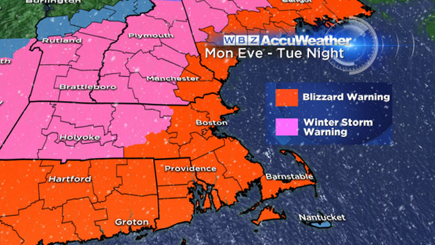
Blizzard conditions are extremely likely for a good portion of eastern Massachusetts late Monday night into the day on Tuesday. This is not to be taken lightly. Driving will be near impossible at times with whiteout conditions, a potentially life-threatening situation.
I would advise avoiding travel if at all possible beginning late Monday night. And good news for the kiddoes, I would imagine that nearly all schools will close on Tuesday and a large majority on Wednesday as well.
Timing
Let's break down this storm hour by hour, day by day...
MONDAY
Noon -6 p.m.
The calm before the storm. Winds will begin to pick up out of the east-northeast causing some light ocean-effect flurries. By 5-6 p.m. the initial band of steady snow from the nor'easter will come ashore along the South Coast and Cape Cod. I do not anticipate any travel troubles through 6 p.m.
6 p.m.-Midnight
The storm begins. Steady snow overspreads all of Southern New England. Northeast winds steadily increase, gusting 25-50 mph along the coast by midnight. Snowfall rates of an inch per hour will become quite common over southeastern Massachusetts where some heavy banding sets up. By midnight there should be about 1-3" of snow on the ground north of the Mass Pike. South of the Pike total snowfall will range from 3-6". Roads conditions deteriorate very quickly.
TUESDAY
Midnight-6 a.m.
Blizzard arrives. The storm will begin to peak after midnight. Snowfall rates could range from 1-3" per hour with very heavy bands rotating northward. Sustained winds between 20-40 mph across all of eastern Massachusetts with gusts 40-60 mph. Right at the coastline and particularly over Cape Cod and the Islands, wind gusts could exceed 60 mph, reaching near hurricane force (74 mph). Whiteout conditions will make driving, walking or generally existing outdoors impossible.
Everyone in Southern New England will wake up to a tremendous amount of snow. 6-12" north of the Pike and 12-18" south of the Pike. Our first high tide of concern is around 4:30 a.m. Tuesday. Even though tides will not be astronomically high, the sheer force of the winds will pile up a lot of water along the coast. Astronomical high tide in Boston Tuesday morning is 10.5 feet. There could be a storm surge up to 3 feet, which would result in moderate coastal flooding and some pockets of major. Seas just offshore will build to between 20-25 feet!
6 a.m.-Noon
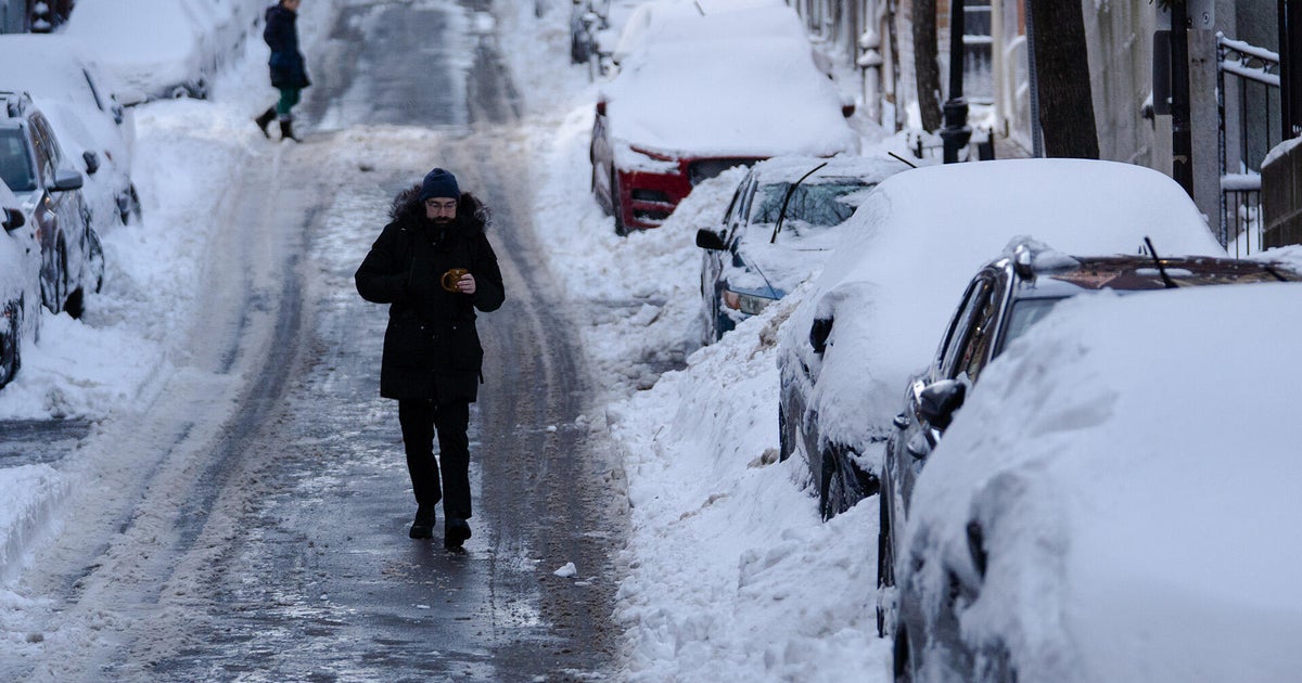
The blizzard continues. The relentless snow and wind continue through Tuesday morning with pockets of whiteout conditions. Snowfall rates will vary with banding. In the heavy bands, up to 3" per hour is still likely. By noon on Tuesday expect 12-16" on the ground north of the Pike and 16-20" south of the Pike. Winds will continue to howl but start to veer to a more northerly direction. Gusts between 40-60 mph will still be common and up to 70 mph on Cape Cod. Needless to say travel will be near impossible on Tuesday morning.
Noon-6 p.m.
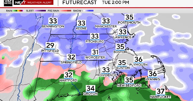
Slight improvement. The peak of the storm will be ending, however the center of the storm will remain very close by, not too far from Nantucket. Snowfall rates will decrease to an inch per hour or less. By 6 p.m. on Tuesday expect 12-20" north of the Pike and 18-24" south of the Pike. About 90 percent of the total snow accumulation will be done at this point.
Winds will remain powerful but out of the north-northwest, mainly an offshore direction. Astronomical high tide in Boston Tuesday evening will occur at 5 p.m. and be at 9.5 feet, a foot lower than the AM high tide. With winds also more offshore, I wouldn't expect the coastal flooding to be quite as severe as the prior tide. One location to watch would be in Cape Cod Bay. Winds there will be from the ocean and water will pile up and splash over vulnerable locations.
6pm-Midnight
Getting there...The shield of steady snow will be eroding into bands and snow showers. The snow will actually stop in some areas at times. Additional accumulations will be small, only another coating to a few inches. Winds will remain very busy out of the northwest, gusting 20-40mph with a few final peak gusts to 50 over Cape Ann and Cape Cod. Let the cleanup begin!
WEDNESDAY:
Midnight -6 a.m.
Digging out. The final bands of snow will rotate through, dropping our last inch or two of snow after midnight. The storm will begin to finally lift north and east, away from New England. Winds stay gusty but not damaging. High tide at 5:30 a.m. shouldn't be a concern with winds now pushing offshore.
Final Snow Totals:
Cape Cod/Islands: 8-12" on the extreme Outer Cape and Nantucket due to some mixing and low snow ratios. Snow totals increase dramatically traveling west down Route 6, up to near 2 feet at the canal.
Southeastern Massachusetts including South Shore, South Coast, Norfolk, Plymouth and Bristol Counties: Right now this appears to be the "jackpot" area. 20-30" are easily within range here.
Boston area, nearby suburbs: 18-24", again, nearing a top 5 event all-time in Boston if we reach 2 feet.
North and West of Boston including I-495 area from Lawrence to Marlboro and out to Worcester, most of Essex, Middlesex and Worcester Counties and Southern New Hampshire: Same deal, 18-24"
Farther north and west including Western MA, Southern VT and Central New England: A bit farther away from the storm and the heavy banding, so slightly less snow totals. . . 14-20"
Northern Ski Areas: Not the jackpot region but they will take it. Easily a foot of fluff up there perhaps up to 16 or 18" in spots.
The prediction in the fall from most forecasters (including the WBZ Weather Team) was for an "above average" snowfall season in Boston. In fact our official forecast was between 55-65" of snow this season in Boston.
Well, before yesterday, it sure didn't look like that was going to be a reality. Boston received 5.1" on Saturday, certainly nothing to write home about, but enough for our biggest snow storm in nearly a year. More importantly, it looks like it was just the spark that Mother Nature needed. The snow spigot has been turned on, and the dam is about to burst.
So there you have it. It goes without saying but please stay tuned to updated forecasts over the next 24 to 48 hours. This is one of those storms that you really do not want to mess with or take any chances on the roads or outdoors in general. Stick with WBZ on air and online for frequent updates.
Follow Terry on Twitter @TerryWBZ
