Another Warm-up...
A weak surface coldfront along with an upper level vortmax is providing enough instability for some evening flurries. It is absolutely hilarious how excited folks are getting after seeing these flurries...just goes to show how desperate we are to see some snow around these parts. There will be another round of flurries tomorrow morning as the next surge of warmth works in but by afternoon temps will be clearing 40 degrees with some partial sunshine.
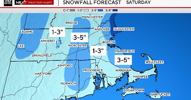
SW flow in the atmosphere will provide even warmer temps for Saturday with highs 45-50 then a coldfront will cool us off for the end of the weekend and early next week as high slip back closer to "normal" levels.
The pattern gets more amplified at the end of next week, this will effectively "catch" a large, mature storm in the Deep South in usher it north into New England. The warm up preceding it will prevent much if any frozen precip in New England so we are looking at another soaker. But the departing storm will drive cold into the East that will likely have staying power as we roll through the rest of the month.