Another Round of Snow...
This time around we are talking about an unprecedented October Nor'easter very capable of breaking records for snowfall in the month of October. Unlike last night's snow event this one will not have a minimal impact...this one will have a major impact throughout all of New England. First of all this has the classic mid-winter snowstorm signature...cold high to the north and a powerful, strengthening surface low loaded with moisture that tracks SE of New England. If this were January or even December this would be a no-brainer 10-20 inches for most of us...but it's not and there are many mitigating factors in play. The biggest factor being the ocean waters are still in the 50s and the wind...for a time...will be coming in off the water. This will keep surface temps above freezing so that even if the flip to snow occurs or there is a rain / snow mix accumulation will be tough. This is where it gets tricky...wind around high pressure is clockwise and wind around low pressure is counter clockwise therefore the NE component.
But when the pressure centers get strong enough they overcome the turning of the wind and literally flow from high to low...and therefore would be out of the north...that's called ageostrophic flow. This would likely occur after dark when the low is approaching New England from the south and that's when the rain / snow line will work toward and then thru Boston. Pinning down that exact moment is almost impossible but my thinking now is that it will be near or shortly after midnight and that would give us around 4-6 hours for a chance to accumulate.
Watch Todd Gutner's Forecast:
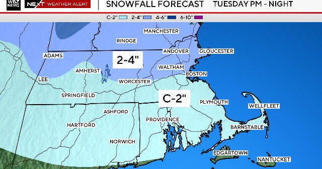
With that said, there still won't be typical winter snow ratios...due to warm ground and the previous rain, ratios will be closer to 5:1 and that is why we forecast 1-3" of heavy wet snow for Boston at this time. 128 to 495 would see 3-6". 495 and beyond would see 6-8" with the higher peaks getting as much as a foot! Again, keep in mind that 128 and inside of it can be highly variable...for example, Arlington Heights will get more than Somerville due to elevation.
Along with the snow, winds will be gusty and gusts over 40mph hour will occur. Trees still have most of their leaves and snow will get caked to them adding weight and the leaves will act like sails making limbs and powerlines very vulnerable...there could be major tree damage for Interior NE where the heaviest snow falls and numerous power outages as a result!
Lastly, the coast...while tides are very high thanks to the new moon...in fact, some of the highest of the year, when the winds have an easterly component it will be near a low tide and when the storm swirls by the high tide won't be astronomically as high so at this time we are looking at minor with pockets of moderate coastal flooding...looks like we will dodge a bullet there.
All storms are difficult to forecast but being that this one is in October and there really are only a handful of comparable events a lot can go wrong. We'll just have to deal with those curveballs as they get thrown.