All Is Calm, All Is Bright...
What can you say? After the second warmest November on record, you would think it could not last. There were signs of cold returning in December..but it just never locked in. So here we are...in a MILD December of 2011...averaging close to 6 degrees above normal for the month. 21 of 23 days were above normal. Only a trace of snow in Boston. Incredible. Especially when you compare it to last year.
Cold Canadian high pressure is getting ready to push into New England tonight. A cold front is pushing through which has triggered a few scattered light rain or snow showers. Skies will be clearing with the passage of the front as lows drop down into the 20's and teens in the western valleys overnight. The 1-4" of snow across the north in the past 24 hours will likely make for areas of black ice on secondary roads late tonight. Expect a refreeze where some of the snow melted today which could make it quite slick in spots across the north. Ski areas picked up about 4-8" of new snow which is exactly what they needed to kick off the holiday weekend. Plenty of snow making is allowing resorts to be open with limited terrain....but terrain is definitely starting to be more abundant. What a struggle it has been so far.
Watch Joe's Forecast
High pressure builds in over us Saturday supplying dry cold air with winds out of the North. Highs will be in the upper 20's and Lwr 30's in the sunshine. Ocean effect clouds and flurries will hang tough at the coast from Boston to the Cape. A light coating is possible on some grassy surfaces. Light snow and furries will diminish in the afternoon...along with clearing skies. Clear & Cold for Christmas eve with lows in the teens, 20's coast.
High pressure pulls off the coast Christmas day. Ocean effect snow showers will still be possible on the Cape. Sunshine in the morning will fade to increasing cloudiness. SW winds ahead of an approaching cold front will bump temps into the upper 30's near 40. A stong vortmax will push through Sunday night which could trigger a few scattered snow showers for another light coating across the north. Once this energy is off the coast it will deepen into a stronger low...but it just can not get it's act together in time over us.
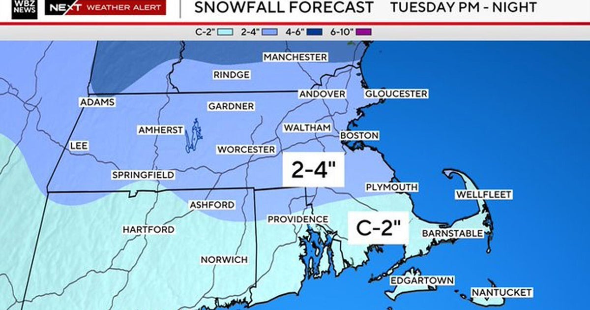
With the front offshore, breezy NW winds will kick in for a sunny breezy Monday near 40. A low will come out of the Gulf and will move towards New England for the mid week. Warming SW winds will spike our temps back to near 50 ahead of the approaching rainfall. Once again...it looks like a warm storm at the onset. Rain will become heavy Tuesday night with the low tracking over southern New england. Gusty winds will accompany the low. Heavy wet snow will be possible on the nW track of the low which will likely be directed into Northern New England. The track of this is still very unclear and will evolve in the coming days as always. Behind this low...a more seasonal airmass to end the week in the 30's with a mix of sun and clouds.