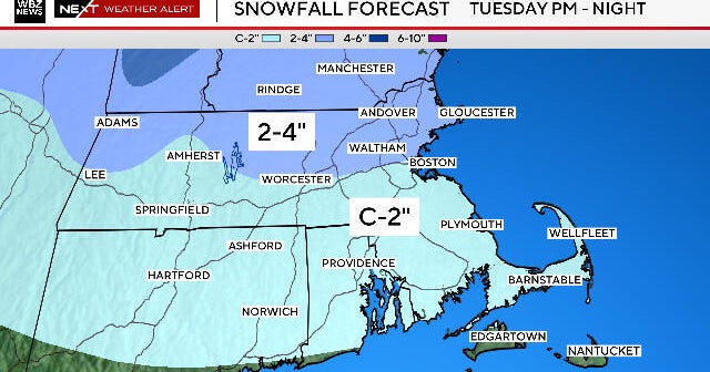
A Touch of Snow...
A storm system is developing to our south right now and moisture is expanding into the Northeast as a result. Southern New England will be on the northern fringe of this system so we won't get much as very dry air present over the region will chew away much of what falls. Despite that, some snow will reach the ground in SE Mass and later tonight and an inch looks likely on Nantucket with some thinner coatings possible over the rest of extreme SE Mass...nothing will reach Boston.
Following this system we will actually see a warm up...SW winds in the mid levels and westerly winds at the surface will provide some good mixing and highs in the 40s even close to 50 again will be seen both tomorrow and Friday.
All eyes are on the weekend and a series of arctic fronts that mean business. The first will pass through on Saturday so temps will be falling through the day. The bigger question with it is can we manage to develop an area of low pressure along it to spin up some snow. The answer still isn't well-defined but at the very least we'll see some snow showers with its passage. The phasing between the southern and northern stream looks feeble and even if a storm materializes we'd be hard pressed to see accumulations over a couple of inches. More interesting will most likely be the second arctic front that passes through on Sunday...snow squalls will be possible and temps will fall during the day. The wind will be very gusty and windchills will be harsh in the single digits.
The arctic outbreak will last through Monday then another surge of 40+ temps works back in to New England.