A Remedy...
I, along with many others (maybe not all of you snow lovers on this blog), have the Winter blues. I was driving around taking care of some errands today and drove past Russells Garden Center on the Wayland-Sudbury line...I decided to stop and check it out. As soon as I walked into their greenhouse I immediately perked up! The site of the green plants and the smell of the flowers...honestly it was an instant remedy. There are numerous year round garden centers around the area and I highly recommend hanging out in one them for a while it will fast forward you through this harsh Winter...albeit only temporarily.
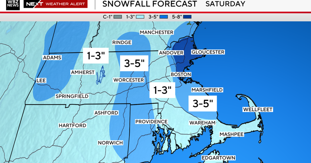
And we are getting only a temporary lull from the storms as another one is likely to arrive Saturday afternoon. The system is very unorganized and will remain that way until it closes in on New England. Moisture will dart out ahead of it and spread in Saturday midday...temps will be marginal at that point for snow so a rain snow mixture is likely at the start. Even if there is snow falling in the early afternoon it will have a very tough time accumulating as surface temps will likely be slightly above freezing at that point. As the afternoon rolls on and we get into the early evening the upper level dynamics sharpen up and intensify the surface low as it passes bye this will effectively suck down cold air from above and draw down colder air from Northern New England so any rain will change to a wet snow and that line will crash through the Cape late in the evening. There is discrepancy amongst the models as to how much QPF will be left over once we are cold enough to accumulate. The 18Z run of the GFS has a much weaker 300mb jet streak and thus a weaker vort max and less QPF...the NAM is much more pronounced and has support with the stronger vort from the 12Z run of the EURO and to some extent the Canadian too. So my though is for the higher QPF on the backside of the storm when it is strengthening and could be around .5" liquid. So, in areas north of Boston that are all snow there could be as much as 6-8" of heavy wet snow...in the city we are most likely looking at very low ratios and perhaps no more than .5" liquid in the cold enough air so I'd say a good guess would be for a few slushy inches in the city...amounts taper off to a coating over the Cape and Islands at the tail end. I will say that a lot has to go right to get the maximum snow out of this one...no cold high...mild during the day...timing of the strengthening and thus QPF issues...but the way this Winter has gone I'm not betting against it from happening yet.

