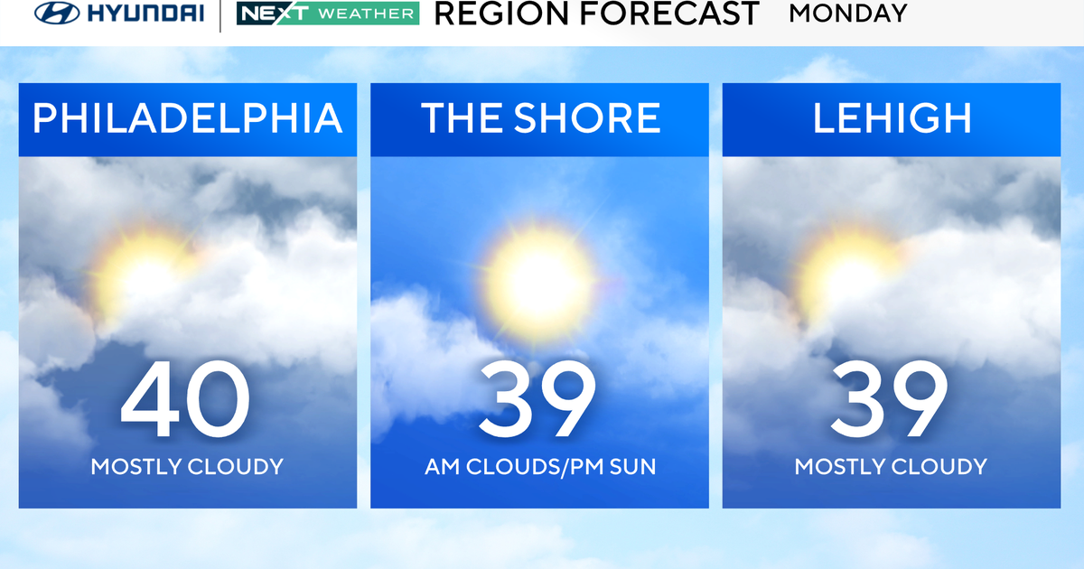
A Look At The Week Ahead...And A Glimpse Into 2012
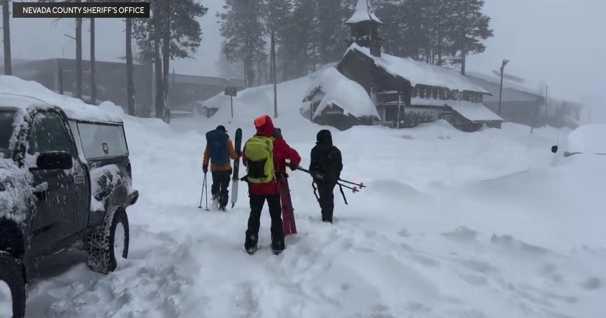
Many mountains got a covering of white after last night's storm (and it's still snowing). Here are the overnight totals:
Burke Mountain: 4"-6"
Jay Peak Resort: 4"-6"
Smugglers' Notch Resort: 4"-6"
Stowe Mountain Resort: 8"-10"
Southern New England had a few showers move though overnight. That moisture has been freezing in SNH and NE MA this morning with temps below freezing. This has created areas of black ice..so there are slippery spots early this AM. An area of low pressure off the coast continues to deepen as it pulls away. Breezy NW winds will develop today as this low departs with cooler drier air on the move behind a cold front pushing off the coast. Winds will gust to 20 to 30 mph adding a chill to the air. Temps in the 30's this AM south will climb only into the Lwr 40's by the afternoon because of the cold air advection from Canada. Cooler 20's across the north will keep temps in the 30's. Skies are increasing with sunshine as high pressure builds behind the departing cold front. Though temps are not all that cold behind the front. Look for temps to drop off quickly tonight with the setting sun falling into the 20''s with clear and calm conditions overnight. Temps will level off towards dawn with a wind shift to the SW.
Tuesday will be a warmer day with SW winds as high pressure pulls off the coast and wraps in the warmer air into the northeast. Highs will be climbing into the 40's nearing 50. Morning sunshine will quickly be fading to mostly cloudy skies by afternoon. Clouds will be thickening in advance of rain which will be pushing into western New England by sunset. The low will be coming out of the gulf of Mexico, tracking right up through the mid-Atlantic states and finally through New England by Tuesday night. This will be an inside running storm which will come with plenty of warmth and moisture...so there is very little threat for snow or mix. Rain will come down heavy for a time Tuesday night with the potential for some embedded thunder, and upto 1" of rain. Strong winds from the SE could gust to 40+ at the south coast and south shore as this low barrels through. The fast progressive nature of this storm will keep flooding to a minimum
By Wednesday at dawn, the storm is over Northern Maine with the heaviest rain offshore. The storm will get stronger as it lifts north into Canada. With high pressure following in from the Great Lakes winds will be strong on Wednesday from the NW with gust to 40+. Mild air will be in place to start in the morning...but temps will plummet through the day into the 30's and eventually into the 20's by sunset as skies gradually fill with sunshine. Cold sunshine Thursday in the Lwr-mid 30's.
Clouds will be increasing to end the week as northern latitude states will find themselves on a boundary between cold pressing from the north and mild air to the south. A weak clipper will washout over us Friday with increasing clouds with the chance of a few hit or miss rain or snow showers. Saturday, a more classic looking Clipper, will slide in from the Great lakes and track close to New England. Hard to say with any confidence what type of precip this will end up being. Right now, it looks like showers south with temps in the mid 40's. Snow showers north. But a farther south solution will bring in colder air and we could be seeing some snow showers mixing in. So in summary....a light mix of rain or snow is possible Saturday. As this low pulls away we could even see some lingering light snow or flurries into the First night festivities with temps near 32. At this point, it looks like a mainly dry night. Still plenty of time to adjust in the coming days. New Years day looks dry, with a seasonal chill.
Still no signs of a wintry pattern locking in through at least the middle part of January. There will be small windows where cold may interact with mositure for the chance of snow...It just does not look very impressive yet. A Trough will likely become established in the east the next 2-3 weeks which should make for more active wintry pattern. There is still some hope...for those of us starved for some winter action from the atmophere. Certainly a different year from last...