A Little Snow, A Lot of Rain
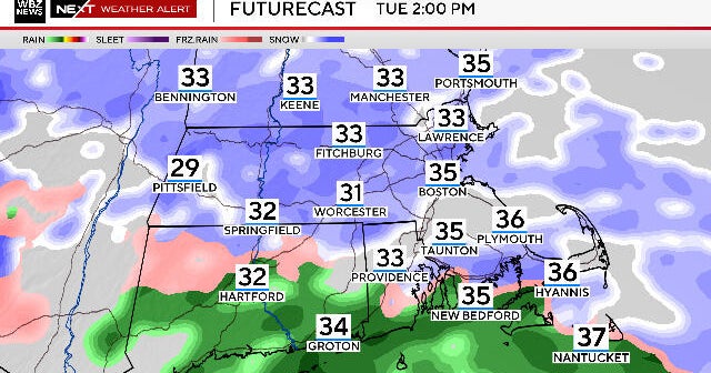
My thoughts from last night actually still stand. I still expect widespread dustings tomorrow night to as much as an inch as models typically underestimate warm air advection clouds and precip. I also think that the cold will be very tough to dislodge so that the only places to mix with rain will be on the South Coast, Cape and Islands. In fact, I think tomorrow will actually be colder than today...we are going to start out in the single digits with a good leftover nocturnal inversion creating a very stable atmosphere with very little mixing so that mid level temps won't be able to mix down. Plus, these are the shortest days of the year and we won't even have sun all day due to increasing high clouds...high overcast by afternoon!
As suspected, yesterday's 18Z run of the GFS was a fluke...sure, it's still showing a slightly colder solution, but even still it's mostly rain. The EURO holds firm and that is my model choice with some intense rain likely Sunday night with a coldfront or occluded frontal passage.