3rd of the Week!
At the beginning of the week Meteorologist Joe Joyce and I made a gentleman's bet for how much snow Boston would have by Friday evening...the over/under is 10"...I took the under he took the over. To this point Boston has seen 1.9" therefore Joe needs 8.2" to win and I need 8" or less to win...this one is going to come down to the wire...I think we'll be counting every flake...or at least Joe will! Should be fun to watch!
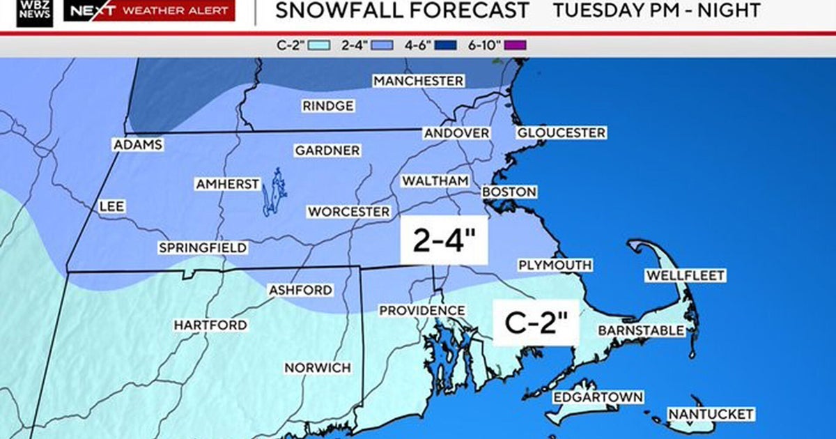
So, obviously models have increased their QPF over the last 18 hours or so and the track has shifted west as well...what else is new this Winter?!?!? This means a little more snow for us than we were thinking yesterday...and more in line with what I HAD been saying earlier this week (wish I didn't bite on the lighter QPF). So we are looking at a general 5-8" across most of Mass and Southern NH. This is going to be a very fast mover and the accumulating snow will mostly only fall in the AM so it's going to be tough to get much more than 8" but I do think that with good ratios a few spots may get up to 10". With the closer track warming and mixing will now be introduced to SE Mass holding down totals to a range of about 2-5" either side of the Canal and sneaking up through parts of the South Shore and down through Buzzards Bay...and just a couple of inches at the start over the Outer Cape and Nantucket. I have a feeling that most will fall into that 5-8" range because places that don't get that much QPF will have much higher ratios to offset the lack of moisture and places that get the higher QPF will have lower ratios due to an influx of milder air making the snow heavier and wet by the end...we'll see. In the end, while the storm will be intense...it will also be flying through and I expect a really nice sunset tomorrow evening...that's right, heavy snow in the morning...some sunny breaks in the afternoon...what a day!
The arctic air is still on track (unfortunately) to invade New England over the weekend. Lower 20s on Saturday...a reinforcing arctic front Saturday night (snow shower possible) will usher in even colder air meaning highs in the teens Sunday and Monday with overnight lows likely going subzero.
Next week's storm is no guarantee at this time but the trusty EURO has biggie in here late Tuesday not departing until Thursday morning...yikes!!!
As always, any help during the storm will be much appreciated...we thank you in advance.