1st Day Of Spring...Cold & Wintry
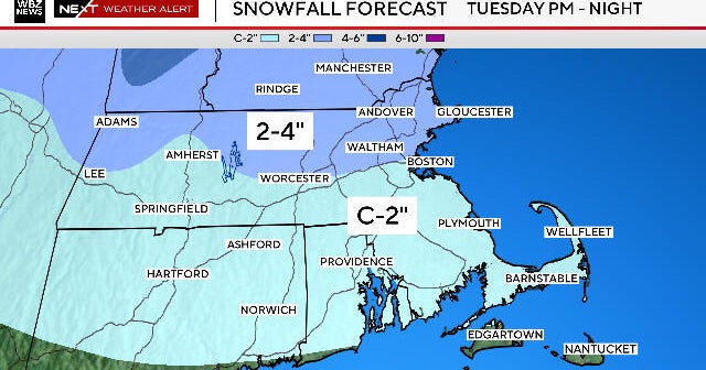
1st Storm: Winter Weather Advisory ... An area of low pressure will track across Southern New England today producing a plethora of precipitation. It should be a rain/snow mix from Boston to points south before transitioning to rain this afternoon. However, cooler temperatures for areas northwest of the city will continue to support mainly snow through the afternoon. So, snowfall accumulations from 2-5" are possible for areas in northern Worcester County and southern NH. Otherwise, <1" is expected for Boston and areas within the 495 corridor. The South Coast/Cape/Islands will receive a trace to none. Highs will hang in the upper 30s to near 40F. Winds will also be gusty at times from the south and southeast.
A 2nd storm will be approaching our neighborhoods Wednesday afternoon through midday Thursday. This is one that shows potential for light snow accumulations for areas north and west of Boston. This would include the same areas receiving snow today.
For the first full week of Spring, temperatures area going to be stuck in the 40s. No major warm-ups in the near future.
Melissa :)