Weather Watch: Thunderstorms Are On The Horizon
BALTIMORE (WJZ) -- Marylanders should prepare for stormy weather this week.
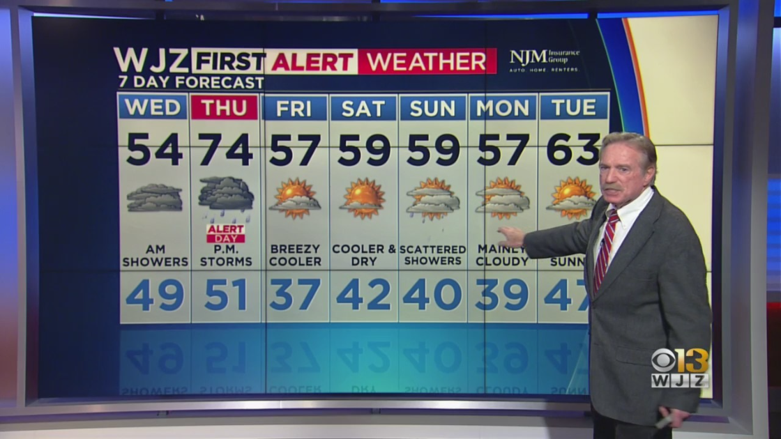
Most folks endured milder temperatures Tuesday after a frigid Sunday and Monday.
There was a morning low of only 22 degrees but the city did manage to see 47 degrees on Tuesday afternoon.
That's 13 degrees below normal though.
Overnight, a warm front will begin to develop and this will cause clouds to increase by early Wednesday.
There is a small chance that some very light wintry precipitation may form for a few hours before things warm up and clouds break, especially in far Western Maryland.
By Wednesday afternoon, the weather will warm back up to the mid-50s.
There is a winter weather advisory in the early morning for the Washington County area.
But a much warmer day is coming on Thursday, which should top out in the low to mid-70s.
After that, people will need to prepare for a weather shift.
A cold front will be approaching by evening, and this will likely initiate showers and a few isolated strong thunderstorms sometime in the late afternoon or evening.
The Baltimore region is in a slight risk zone for these storms with a marginal risk in far western areas.
Once the front moves through, clearing and breezy conditions will follow on Friday along with cooler temperatures.
Due to the risk of these storms, WJZ has designated Thursday an alert day, so be weather aware.
A drier, more seasonal weekend is coming too.