Maryland Weather: Severe warning & watch issued for storms

BALTIMORE-- A severe thunderstorm watch has been issued for the entire WJZ viewing area until midnight. Damaging winds are the main threat from storms.
A severe thunderstorm warning is in effect for south-central Anne Arundel county until 10:45 PM. Severe storms are moving into this area capable of producing wind gusts up to 60 mph and hail. Please get inside and away from windows if in the path of this storm.
A severe thunderstorm watch has been issued for the entire WJZ viewing area until midnight. The watch includes Howard, Anne Arundel, Carroll, Baltimore, Harford, Cecil, Kent, Queen Anne's, Caroline, and Talbot counties along with Baltimore City. In the watch area, thunderstorms may produce wind gusts of 60 to 70 mph along with wind damage and power outages.
FIRST ALERT WEATHER DAY continues for the possibility of severe storms through midnight. Damaging winds is the biggest threat from these storms. In addition to damaging winds, heavy rain and intense lightning are likely with storms.
A CODE ORANGE for air quality for a few of our eastern counties near the I-95 corridor.
Temperatures Wednesday afternoon reached the middle to upper 90s. Feels like temperatures topped out in the triple digits across many neighborhoods. The heat will quickly subside in areas that receive thunderstorms.
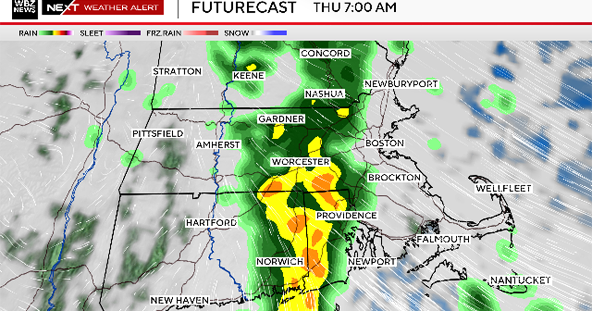
Severe thunderstorms are likely between 10 PM and 1 AM. Damaging winds, intense lightning, torrential downpours, and an isolated tornado cannot be ruled out. Storms are moving from southwest to northeast and will end shortly after midnight. Stay with WJZ for additional information and possible severe weather warnings as storms approach.
Storms will taper off to showers after 1 AM and linger in the area until around sunrise. Low temperatures tonight will be muggy in the lower 70s.
Thursday will start muggy, but humidity levels will fall during the second half of the day. Expect clouds giving way to sunshine with another hot afternoon. Highs will top out in the lower 90s.
Friday will be fantastic with sunshine and temperatures in the middle to upper 80s with low humidity.
The weekend looks extremely muggy and unsettled at times with scattered showers and thunderstorms. Saturday could feature storms at anytime with highs in the upper 80s. Sunday's storms may be focused to the afternoon and evening hours. Sunday will be another hot day with highs in the lower 90s. There is a chance of some severe weather Sunday with the eastern shore of Maryland being in the area of the greatest risk.
After storms exit Sunday evening, refreshing and comfortable air returns to the area Monday and Tuesday. Highs will top out in the middle 80s.
Enjoy the break while it lasts, more heat and humidity return to the area next Wednesday into the 4th of July.