Big relief from heat Monday in Maryland, but sweltering temps return Wednesday

BALTIMORE -- Baltimore endured its second day in a row of record high temperatures Sunday. Big heat relief arrives Monday!
Baltimore experienced its second day in a row of record-high temperatures.
BWI Thurgood Marshall Airport reached 98 degrees just before noon. This high temperature broke the previous record high for date of 97 set back in 2010 and 1894.
On Saturday, BWI Thurgood Marshall set a new record high of 101 degrees, which was the first 100-degree temperature observed during the month of June since 2012!
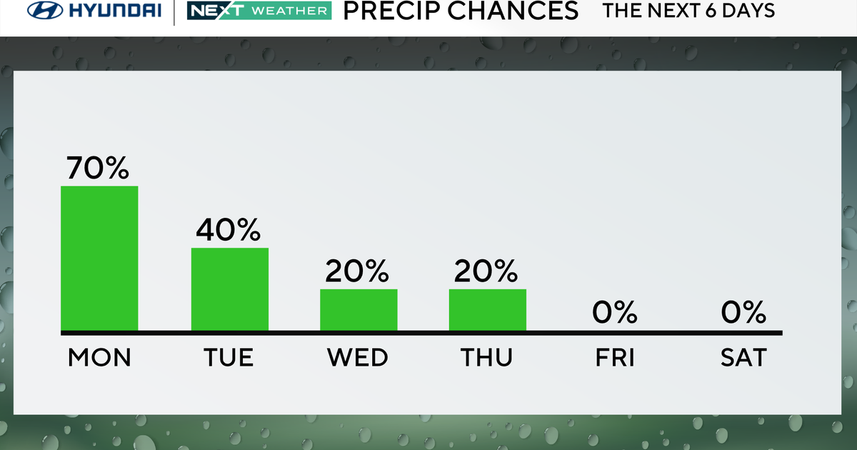
Our WJZ ALERT DAY has been cancelled with the dangerous heat easing and the isolated severe storms exiting. Overall, the trend has been our friend as the extreme heat has been backing off this evening with the abundant clouds and scattered storms. As a cold front approaches the area, a few more isolated to scattered showers & storms will be possible through the overnight.
Overnight lows tonight will be warm and sticky with temperatures only falling into the middle to upper 70s. A few more isolated to scattered showers & storms will be possible through sunrise Monday.
Monday both the heat and humidity back down in a big way. Gusty northwest winds behind a cold front that crosses early Monday morning will flush out the dangerous heat and humidity. Expect sun & clouds along with gusty northwest winds at 15 to 20 mph, gusts to 30 mph. Humidity levels will plunge throughout the day. Highs will top out in the middle to upper 80s.
Sunny and hot weather returns Tuesday, but the humidity will not be around this time. Expect highs in the lower 90s.
Our WJZ First Alert Weather Team has issued an ALERT DAY Wednesday for extreme heat and humidity. Highs will surge back into the upper 90s with feels like temperatures at or around 100 degrees. Please take all of the steps to protect yourself, the elderly, and your pets during this period of intense heat.
Strong to severe thunderstorms will be possible late Wednesday afternoon and evening. Some storms could contain damaging winds and hail along with intense lightning. These storms forming along and ahead of a cold front will help break the extreme heat Wednesday night and Thursday.
Humidity levels begin to plunge Thursday afternoon with highs near 90. A morning shower or thunderstorm is possible Thursday before the drier air arrives. Friday looks beautiful with sun & clouds and highs in the middle to upper 80s.
Heat and humidity are back next weekend. Saturday looks like the drier day, but hot and muggy all day long. Highs in the lower 90s, but feeling like the mid to upper 90s with the humidity. Sunday looks steamy as well with highs in the lower to middle 90s and feels like temperatures in the upper 90s. Scattered storms are possible late Sunday afternoon and evening as another cold front approaches the area.