Grueling hurricane seasons: our new normal is already here
BALTIMORE -- Tropical cyclones, also known as "hurricanes" in the Atlantic and eastern-central Pacific Oceans, "typhoons" in the western Pacific Ocean, "cyclonic storms" in the northern Indian Ocean, "tropical cyclones" in the southern Indian Ocean, and "cyclones" in the southwestern Pacific Ocean are the largest and most powerful storms on earth.
While these storms possess different labels in various parts of the world, they all have one thing in common, they're dangerous and often deadly.
These storms all pack strong and destructive winds, torrential amounts of rainfall, and storm surges, and are isolated to scattered tornadoes in and around their circulations.
Each year, meteorologists and climatologists track and record the number of tropical cyclones (hurricanes) that developed. Some years are much busier than others; depending on other global natural weather phenomena happening across the world i.e. El Nino, La Nina and Saharan Dust.
Certain weather patterns favor the development of many tropical storms and hurricanes in the Atlantic and Gulf of Mexico, while other weather patterns suppress and limit the number of named storms each year. Despite these fluctuating variables, the common ingredients that support the development and strengthening of tropical storms and hurricanes is quite simple:
Four Ingredients Needed for Tropical Storm and/or Hurricane Formation:
- Cluster of thunderstorms
- Warm sea-surface temperatures (at least 80 degrees). Deep warm ocean water is more favorable for hurricane strengthening than shallow warm ocean water
- Warm and humid atmosphere: extending from right above the ocean to the upper atmosphere
- Upper-level high pressure (light winds in the upper atmosphere), allows tall thunderstorms to build and form and organize around a closed center of circulation.
When all four of these ingredients are present, and a "closed surface circulation", also known as an area of low pressure, forms; then the tropical disturbance is classified as a "tropical depression". This is the first classification of three tropical tiers: tropical depression, tropical storm, and hurricane.
Once sustained winds with a "tropical depression" strengthen to 39 MPH, then the "tropical depression" is upgraded to a "tropical storm" and assigned a name. When the tropical storm sustained winds strengthen to 74 MPH or higher, then the tropical storm is upgraded to a "hurricane". Once sustained winds further strengthen to 110 mph or higher, the hurricane is now considered to be a "major hurricane".
Climate change is, directly and indirectly, impacting the strength and movement of hurricanes and tropical storms. Here are some of the direct impacts of climate change on tropical storms and hurricanes:
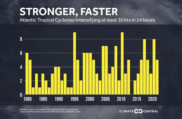
RAPID INTENSIFICATION: The biggest direct impact of climate change is the availability of widespread, warmer than average, sea-surface temperatures. This warm water gives tropical storms and hurricanes an expansive reservoir of 'high octane fuel' to digest, so that they have the ability to rapidly intensify. The frequency at which these storms are undergoing rapid intensification is a direct impact of climate change. Notice in the graph below, the frequency of rapid intensification in tropical storms and hurricanes has increased as Ocean water temperatures have increased due to climate change, especially in the last couple of decades.
There is a strict definition of "rapid intensification", which is given by the National Hurricane Center (a branch of the National Oceanic and Atmospheric Association: NOAA). Rapid intensification is defined as sustained winds increasing 35 MPH or higher in less than 24 hours in a tropical storm or hurricane.
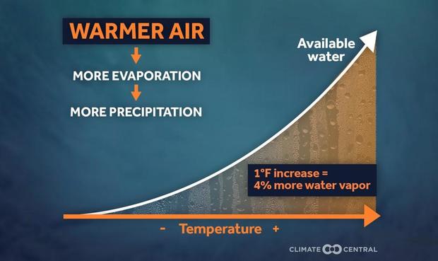
EXCESSIVE TO CATASTROPHIC AMOUNTS OF RAINFALL: Not only are sea-surface temperatures warmer than average from climate change but so are air temperatures. As air temperatures continue to warm, the warmer air has the ability to hold more water vapor than cooler air. Therefore, when hurricanes and tropical storms do form, they have the ability to deliver excessive to catastrophic amounts of rainfall.
Recent examples of catastrophic rainfall from tropical systems are from "Harvey" in the Houston area, and "Ian" this past year (2022) in parts of Florida. Rainfall totals exceeded a foot in many parts of Florida, despite the storm lasting less than 24 hours. Hurricane Harvey dumped record rainfall totals in excess of 30" in parts of the Houston metro area.
Indirectly, climate change may be impacting weather patterns around tropical storms and hurricanes to cause them to move more slowly. This leads to prolonged impacts that last much longer than in normal weather patterns. The slower speed means destructive winds, flooding, and storm surge last much longer over one location than normal; causing more devastation. The link between slower-moving tropical systems and climate change is still being studied, and scientists aren't completely sure how strong the correlation is just yet.
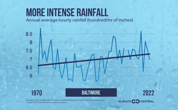
While Maryland, and specifically the Baltimore metropolitan region, has not suffered direct landfall from a hurricane or tropical storm in recent memory; the climate here, like around the world, has warmed too. This is concerning as everyday rainstorms have become more extreme with our warmer atmosphere. An example of an extreme rainfall event from a warmer than normal atmosphere would be the Ellicott City flood in 2018.
Here's a graphic showing how the frequency of intense rainfall events has increased from 1970 to today.
A warmer atmosphere, that holds more water vapor, means that if Maryland does suffer from a direct landfall from a hurricane and/or tropical storm, the amount of potential rain that falls would easily overwhelm drains, storm sewers, road and highway infrastructure, along with the likelihood of water inundating homes, schools, and businesses. We've seen this recently from indirect hits from tropical systems such as "Ida" and "Isaias".
One of the biggest threats tropical storms and hurricanes pose to the state of Maryland is from storm surge. Why? Maryland has over 3,100 miles of tidal coastline vulnerable to hurricane and tropical storm landfalls. Climate change and land subduction have directly caused sea levels in the state to rise at least 1 foot in the past 100 years. All indications are that the sea-level is continuing to rise.
Two ways climate change has impacted Maryland sea-level rise:
- Thermal expansion: the warmer temperatures of the ocean allow the water molecules to expand and become larger. This is one cause of sea-level rise
- Melting ice/glaciers: This melting of freshwater ice draining into the ocean increases the volume of the ocean, leading to another example of sea-level rise
Another unrelated factor to climate change that's causing sea-level rise in Maryland is our sinking coastline. This is a unique situation that's happening in this part of the United States. During the last ice age (approximately 11,000-12,000 years ago), a massive and colossal-sized glacier advanced south and stopped just to our north. As the glacier stopped, the force ahead of it caused the land and coastline immediately south of it to swell upward in height.
Ever since this glacier retreated and melted, the ground is still settling back to its 'normal' height prior to the most recent ice age.
Given Maryland's 3,100 miles of tidal coastline, it's extremely vulnerable to coastal flooding and storm surge. Forecast sea-level rise projections of 3 to 4 feet by 2100 would be absolutely devastating, even without a storm.
Many parts of Dorchester County would be submerged and underwater year-round. Add the potential of a landfalling tropical storm and/or hurricane, the damage would be catastrophic and unimaginable given the lack of direct strikes in this area.
The warming climate also has and will have other effects from the weather during landfalling tropical systems such as tropical storms and hurricanes. Warmer Atlantic Ocean and Chesapeake Bay waters allow for these storms to at least maintain their intensity, if not strengthen, before landfall. This means we will see storms with stronger sustained wind speeds and the threat of more frequent destructive winds from these storms. In addition to destructive tropical storms and/or hurricane-force winds, a warmer climate would support more tornadoes in the rain bands of these storms.
While strong and direct links have been made to climate change and rapid intensification of tropical cyclones, increased rainfall intensity, and greater storm surge potential, links to increase tropical activity (higher amount of storms each year) is low to none. There is no proof that we will see more storms each season because of climate change. In fact, weather patterns may support an equal number of storms or even less per season. However, the storms that form, have the potential to become much stronger, much faster.
Preparation is key. Here are some available links to help you and your family prepare for hurricane season:
Maryland Hurricane Preparation: https://mdem.maryland.gov/Pages/resources-hurricane.aspx#:~:text=During%E2%80%8B%20an%20Emergency&text=Follow%20instructions%20and%20advice%20given,hallway%20on%20the%20lowest%20level
NOAA Hurricane Safety Tips & Resources: https://www.weather.gov/safety/hurricane
NOAA: Develop your Hurricane Plan Now: https://www.weather.gov/safety/hurricane-plan
Red Cross Hurricane Preparedness Kit: https://www.redcross.org/content/dam/redcross/get-help/pdfs/hurricane/EN_Hurricane-Safety-Checklist.pdf
Sea Level Rise Projection Map (Interactive): https://coast.noaa.gov/slr/#/layer/slr/0/-8429465.506344287/4713307.832546824/9/satellite/none/0.8/2050/interHigh/midAccretion
One element of hurricanes that won't be going away any time soon is climate change.
In order to understand how climate change impacts hurricanes, we have to understand hurricanes themselves and what makes them tick. Water temperatures are a big part of that - something climate change has accelerated.
First, you have got to have a source of fuel for the storms - we're talking about water temperatures usually 80 degrees or warmer.
Above that water, You need warm muggy air, and with that warm muggy air, that air is rising up to the top so that's two out of four important ingredients.
Then we look for a cluster of thunderstorms. If you don't have the storms rotating around, you're not going to be able to really intensify a storm.
And lastly, you need light winds aloft. You don't want anything to rip apart that hurricane. That's how normal hurricanes formed during your hurricane season.
But if you change the factors in the ingredients just a bit, including our water temperatures, which are absorbing 93% of the Earth's excess heat, you can get a hurricane on steroids.
It can strengthen quicker, it can turn into a bigger size and you're looking at a monster storm. That's one way climate change can play a role in that it's another way it can is warmer ocean temperatures all year round.
Traditionally, hurricane season is from June 1 to November 30. But for eight of the last nine years, it's gone earlier, and that's because water temperatures have been favorable. So we've been seeing longer tropical seasons in some cases.
