First Alert Forecast: Expect A Severe Storm Threat On Monday
BALTIMORE (WJZ) -- Expect mostly cloudy skies overnight with patchy fog and a slight chance for drizzle or light showers.
Temperatures overnight will fall to around 60 degrees.
Partly cloudy skies are expected Sunday with a chance for afternoon showers and storms.
There is a LEVEL 1 MARGINAL RISK for severe storms on Sunday afternoon.
At that point in the day, there will be the possibility of a few isolated storms producing damaging wind gusts and hail.
Temperatures will reach around 80 degrees by mid-afternoon.
A stronger storm system and associated cold front will move through the area Monday afternoon and evening.
The Storm Prediction Center has a Level 2 SLIGHT RISK for severe storms Monday afternoon and evening.
The greatest threats from these storms will be damaging wind gusts and hail.
Temperature highs will again reach the low 80s.
WJZ is issuing an ALERT DAY for Monday to account for the potential for a few severe storms capable of producing damaging winds Monday afternoon and evening.
Following the stormy weather, the mid-week looks nice.
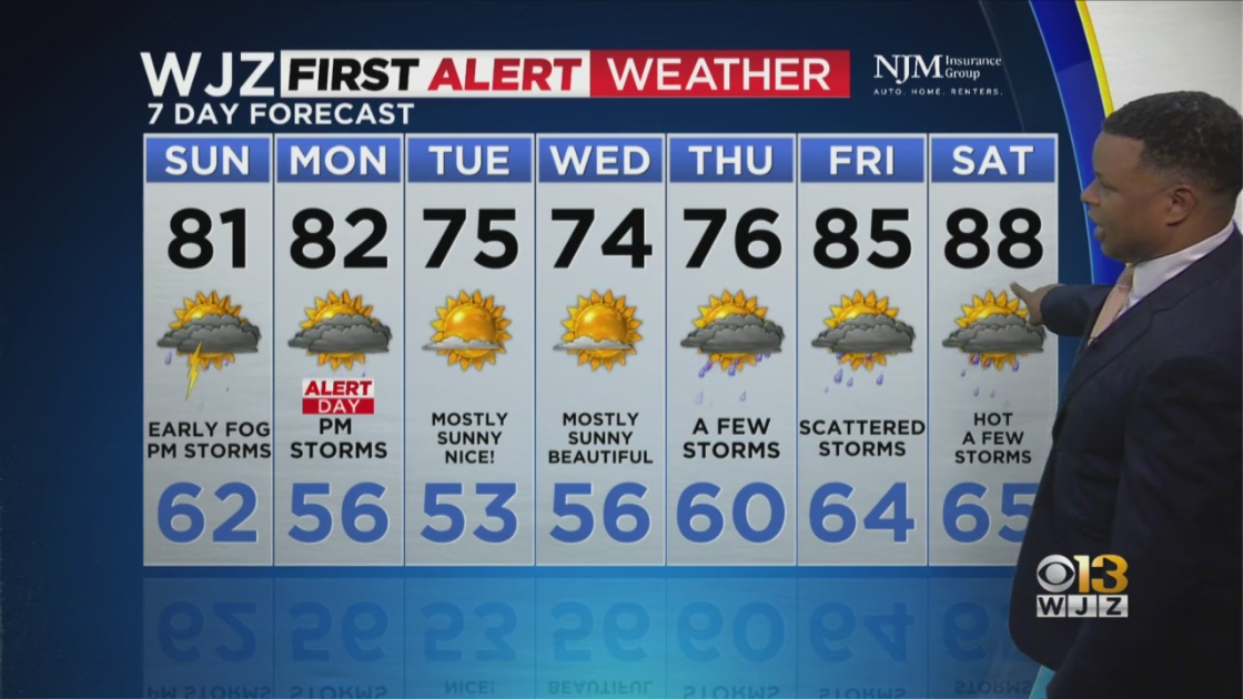
There will be sunny skies on Tuesday and Wednesday with pleasant temperatures in the 70s during the day and 50s at night.
Rain chances return Thursday with temperature highs in the 70s.
A significant warm-up is expected Friday into the weekend with strengthening high pressure in the upper atmosphere.
This will bring possibly the warmest temperatures we've seen so far this season to some areas, with widespread 80s expected from Friday through Sunday.
Don't be surprised if some areas approach 90 degrees next Saturday.
There will be opportunities for a few scattered storms Friday through the weekend too.


