Bridge Fire in California's Angeles National Forest explodes to more than 34,000 acres, evacuations and road closures in place
For the latest development on the Bridge Fire, check here.
A brush fire dubbed the Bridge Fire continued to chew through the Angeles National Forest, nearly growing tenfold within a few hours on Tuesday.
In the afternoon, Cal Fire mapped the fire at about 4,000 acres. Within a few hours, they updated the size to 34,247 acres.
Despite the best efforts from crews on the ground and air the Bridge Fire remains at 0% containment, according to Cal Fire.
The blaze was first reported at around 3 p.m. Sunday near the area of East Fork Road and Glendora Mountain Road in the San Gabriel Canyon area, according to a post on X from the Angeles National Forest.
Road closures and evacuations
As Los Angeles County Fire Department crews worked to extinguish the flames, East Fork Road at Highway 39 was closed, as well as Glendora Mountain Road and Glendora Ridge Road.
California Highway Patrol officials closed Highway 39 at the mouth of the canyon to avoid vehicle congestion in the area.
ANF officials said all forest visitors were ordered to evacuate the area because of the fire and its potential for growth.
San Gabriel Canyon, the East Fork of the San Gabriel River, and Mt. Baldy Road at the Shinn Road intersection were also closed.
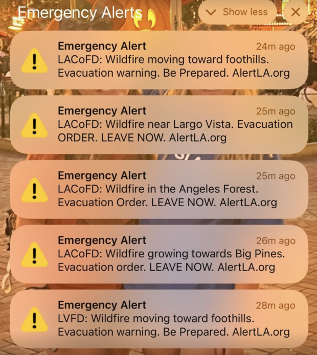
At 7:30 p.m. Sunday, the Los Angeles Fire Department issued an evacuation order for the communities of Camp Williams and River Community.
More evacuation orders were issued on Monday, impacting those living north of the San Antonio Dam up to the Mt. Baldy Resort, as well as Baldy Village from the dam to Baldy Resort, county officials said. Residents were advised to use Mt. Baldy Road to evacuate and not Glendora Ridge Road, which remains closed.
As many as 76 homes were said to be within the evacuation zone issued on Monday.
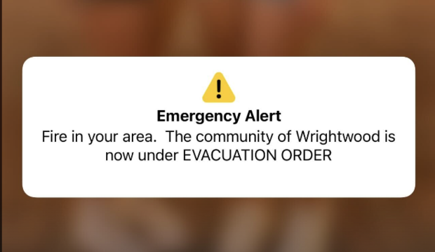
The next day, evacuations were expanded to include the Wrightwood communities and some zones in Los Angeles County.
The evacuations included:
- LAC-E128, LAC-E171, LAC-E170-C, LAC-E172-A, LAC-E172-B, LAC-E172-C, LAC-E144, LAC-E143 and LAC-E172-C, LAC-E126-B, LAC-Q1340, LAC-E-107, LAC-E127, LAC-E105-A, LAC-E126-A, LAC-E126-C, LAC-E106, LAC-E104 and LAC-E105-B.
- Pinion Hills (PIN01 and PIN02) from Wrightwood north to Highway 138 and Lebec Road west to Los Angeles County.
- Lone Pine Canyon from Wrightwood to Highway 138/Lone Pine Canyon Road south to the forest.
Warnings were additionally issued for:
- San Antonio Heights and Upland from the foothills south to 23rd Street,
- from LA County line east to the east city limit, also known as zone SAH01,
- LAC-E169, LAC-E170-A, LAC-E170-B, LAC-E172-D, LVN-E001, LVN-002, LAC-E502, CLA-E003, CLA-E006-A, SDM-E003-A, LAC-E101, LAC-E102, LAC-E103, LAC-E100-A, LAC-E100-B.
To stay updated, use this interactive map outlining the zones under evacuation orders and warnings.
Care and reception centers have been set up at two locations, one at Hacienda Heights Community Center on 1234 Valencia Avenue in Hacienda Heights, and the other at Jessie Turner Health and Fitness Community Center at 15556 Summit Avenue in Fontana.
Authorities established another evacuation center at Victorville Fairgrounds, 14800 7th St, Victorville, after the Bridge fire grew closer to the High Desert.
Animals can be taken to Devore Animal Shelter at 19777 Shelter Way in San Bernardino.
Firefighters hoping to prevent further spread
Early Sunday evening, crews reported that the fire had consumed 800 acres and was being attacked by water-dropping aircraft, both on the ground and from above.
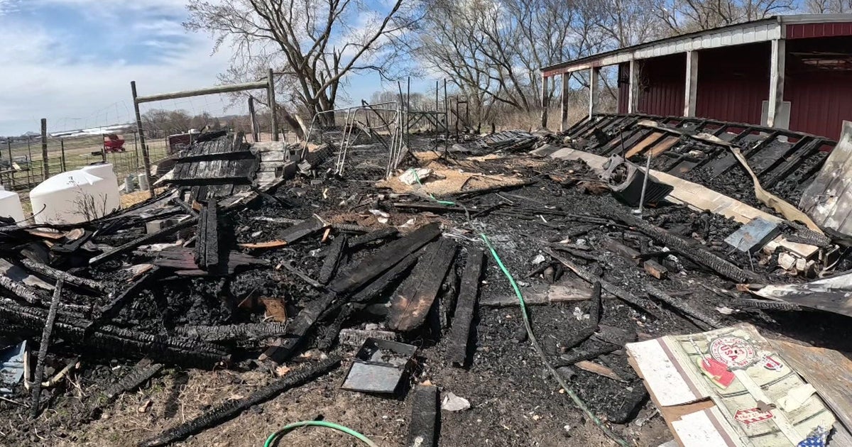
The fire exploded in size the following days, with the burned acreage jumping from about 4,000 to more than 34,000 between the afternoon and evening on Tuesday. Wildfire cameras chronicled the fires consuming the ski resort at Wrightwood as it continued to spread through the Angeles National Forest.
A San Bernardino County Fire Department spokesman said their initial priority was to help people evacuate from Wrightwood before shifting to protecting homes.
"We were doing rescue evacuations for some of our people that are either elderly or can't evacuate on their own," spokesperson Eric Sherwin said.
Firefighters requested help from out-of-state departments and Northern California agencies after two other fires quickly depleted the region's available resources. San Bernardino County declared the Bridge Fire an emergency to hopefully get more resources dedicated to the fire.
This is the second fire of considerable size to spark in Southern California in recent days as the 25,000+ acre Line Fire continues to burn in the San Bernardino Mountains. That blaze more than doubled overnight, prompting thousands of residents to flee from their homes as county officials issued evacuation orders.
The two fires are separated by about 60 miles by air, drawing a large response from multiple regional departments, which is also dealing with the worst heat wave of the year.
A third fire, the Airport Fire, burned over 19,000 acres in Orange and Riverside counties. While it started in Trabuco Canyon, it quickly spread through the hillside and burned down the mountains toward Lake Elsinore.
Residents and business owners talk about the evacuation
Thousands of people in Wrightwood fled from their homes and businesses after the Bridge Fire increased nearly tenfold in a single afternoon.
Evacuee Jennifer Buttros said the sky had an orange hue as smoke started to encapsulate the town.
"Visibility was mediocre," she said. "It was brown and orange. The air was thick. You could see that it was almost the color of ash."
The explosive growth of the fire caught many by surprise.
"We just went from 4,777 acres up to 34,000 plus acres in one hour," Buttros said. "We're not really sure how it went from 5,000 acres to nearly 35,000 acres in one hour."
Some residents said that while they knew the fire was inching toward the mountain community, they did not get a warning before authorities sent evacuation orders.
"There was no evacuation warning," Leah Potter said. "We just had to run for our lives."
Video shows authorities driving through a community, blaring a message over the loudspeaker before turning on the piercing sirens.
"It can happen fast; this is just a clear example of that — we didn't even get a warning," Robin Daly said. "I don't think anyone is ever prepared, but when the moment comes, you have to do what you have to do to get your family out, your animals out, and get out safely."
While it caught some off guard, many heeded the order, quickly gathering their belongings before leaving.
"We knew the fire was close and everything but we hadn't even gotten a notice yet," evacuee Gino Lewis said. "I just grabbed my cat, and as much as I could ... I got out of there as soon as I could."