Most evacuation orders in Orange County lifted as Airport Fire slows in Riverside County
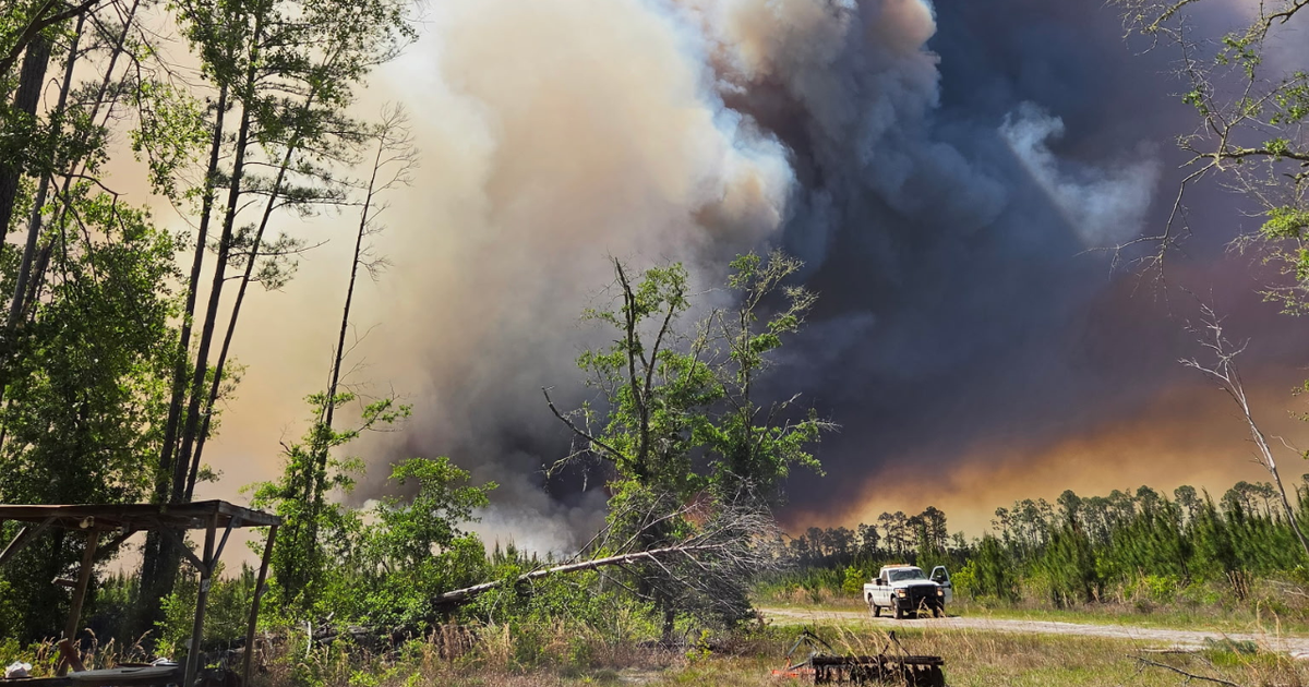
After injuring 14 people, destroying homes and scorching more than 23,000 acres, the spread of the Airport Fire in Orange and Riverside Counties continues to slow as the marine layer and cooler temperatures helped the battle against the blaze.
The wildfire exploded in size overnight Sept. 9 in Orange County's Trabuco Canyon as flames, spurred by west winds, traveled east into Riverside County. Just over one week later, Friday, aided by the temperature drop, it was 42% contained at 23,519 acres, and some mandatory evacuation orders were downgraded to warnings, according to Cal Fire, or the California Department of Forestry and Fire Protection.
Two people have been hospitalized, one with burn-related injuries and one with a medical issue that has not been disclosed. Authorities have not said what their current conditions are. Eleven firefighters suffered minor injuries, Cal Fire officials said.
In all, 152 structures have been destroyed and 31 damaged including 82 homes that were lost, authorities said.
Click here to jump to an interactive map of the evacuation zones.
Fire officials said Friday morning crews are improving containment lines and going into burn areas to extinguish hot spots.
"We are constructing a large dozer containment line from below the fire, starting in Robinson Ranch and behind the communities of Dover Canyon and Coto de Caza all the way to Ortega Highway just in case we have any wind shift or if the Santa Ana winds develop at some point," Orange County Fire Authority Capt. Steve Concialdi said
The blaze was unintentionally started by public works crews that were using heavy equipment in the area on Sept. 9.
It's one of three wildfires tearing through more than 100,000 acres in Southern California this week.
Photos: Airport Fire burns homes and tens of thousands of acres in Orange, Riverside Counties
The blaze moved toward Santiago Peak, threatening a series of radio and television broadcast towers, used not only by local media outlets but also by federal and local government agencies. It creeped up to the base of some of the towers, but the equipment appeared to escape any serious damage.
Just before 2 p.m. Tuesday, authorities expanded mandatory evacuation orders to include homes in Riverside County as the rapidly moving fire began to creep towards Lake Elsinore.
"This is an order by law enforcement to leave immediately," said officials with Cal Fire, or the California Department of Forestry and Fire Protection.
Fire officials said many mandatory orders were changed to voluntary warnings on Thursday.
Several homes were destroyed by the massive wildfire, forcing thousands to remain under evacuation orders for some time.
Ortega Highway was closed between Grand Avenue and Nichols Institute. The area had been under a voluntary evacuation warning, but by late Tuesday morning, mandatory evacuation orders were issued for areas along the highway near Caspers Park.
The Orange County Fire Authority dubbed it the Airport Fire as it started near a remote-controlled airplane airport on Trabuco Creek Road. The flames quickly grew, burning through vegetation on the hillside to more than 5,400 acres within hours.
Blaze approaches site of 2018 Holy Fire
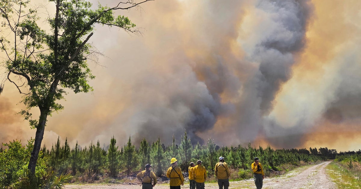
As the Airport Fire exploded in size, Orange County Fire Authority deployed around 1,000 personnel, including hand crews, helicopters, and fixed-wing aircraft, to extinguish it before it reached homes.
Two OFCA firefighters were treated for heat-related injuries before being taken to a local hospital. One civilian was also hospitalized after suffering from smoke inhalation. All are expected to recover, according to firefighters.
During a press conference Monday evening, Cleveland National Forest District Ranger Darrell Vance said that the fire was burning towards the footprint of the Holy Fire in 2018, which torched more than 23,000 acres and destroyed nearly 20 structures.
"Obviously, we don't want to make predictions on what we think it's going to do, but we have high hopes that that's gonna assist us with the prior burn scar," Vance said.
On Tuesday morning, fire authorities said the scars from earlier fires in the mountains are slowing progress as the blaze moves away from homes towards the Cleveland National Forest. The following day, Cal Fire said it was continuing to spread.
"The fire continues to spread with the southeastern fronts showing the most growth," Cal Fire officials said in an update Wednesday morning. "The fire made several significant runs at the Santiago Peak communications array this morning."
"The fire has crossed Ortega Highway and is actively impinging upon structures in the area," the 6:40 a.m. update from Cal Fire reads. "As of this posting, it is unknown how many, or to what extent."
On Wednesday, firefighters said that they expected to start making progress on containment in coming days. The following day, the spread of the blaze was finally slowed down and some evacuation orders were downgraded to warnings.
The latest on evacuation orders and road closures can be found here. Below is an evacuation of the evacuation zones.
Evacuation Map
Riverside County impact, evacuations expanded
Late Monday, the Riverside County Fire Department had issued evacuation warnings for people living on the other side of the Santa Ana Mountains. By 2 p.m. Tuesday, some warnings were upgraded to mandatory evacuation orders.
As the fire continued to rage Tuesday afternoon, fire officials said that it had jumped Highway 74, more popularly known as the Ortega Highway, and was burning well into Decker Canyon.
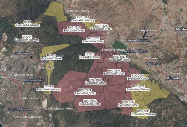
As the fire continued to move towards homes in the area, 1,300 of which they said were threatened at the time, Cal Fire officials noted their concern about the "Elsinore Effect," which are up-canyon winds that are normal during the day but switch directions in the afternoon, blowing down-canyon towards homes in the foothills.
"We are actively trying to go as direct as we can with the fire," said Cal Fire's Todd Hopkins. "We have 45 surge engines into the community of El Cariso, plus I believe we sent three more surge strike teams from Orange County over into El Cariso that is doing their best efforts to defend any structures."
Authorities established a care and reception shelter at Ortega High School, located at 520 Chaney St. in Lake Elsinore, while an animal shelter was set up at the Jurupa Valley Animal Shelter, located at 6851 Van Buren Blvd. in Jurupa Valley.
School closures
As the wildfire just started to rage in the Santa Ana Mountains, the Lake Elsinore Unified School District announced that all school campuses would be closed Sept. 10 due to the intense smoke lingering over the area.
"This decision is made out of an abundance of caution for the safety and well-being of our students, staff, community and first responders," said a statement from LEUSD officials. "We understand the impact this may have on our families and want to assure you that we will keep you informed throughout the day as the situation develops. Our primary focus is the safety of our school communities."
Late Tuesday, they announced that school was again canceled for the following day as the fire continued to move closer to their area.
Additionally, Corona-Norco Unified School District opted to close Wilson Elementary School, Temescal Valley Elementary School and Todd Elementary Schools on Tuesday due to the proximity of the fire.
In Orange County, both Robinson Elementary School and Trabuco Elementary School, with the Saddleback Valley Unified School District, were closed on Tuesday and Wednesday. Santa Margarita Catholic High School, in nearby Rancho Santa Margarita, was also expected to remain closed on Wednesday after being closed the day prior.
Many residents took to social media to report the raining ash in the area, extending as far south as Temecula on Monday evening.
The latest evacuations, warnings and other information for those affected can be found here.