Winter Storm Watch: Tracking Heavy Rain, Possible Snow Saturday
BOSTON (CBS) - You got to admit, this isn't all that bad. These 50-degree, blue sky days in December sure feel nice. There's not a speck of ice to be found yet on the ponds and the grass is greener than it's been all year. Winter-shminter, maybe we will just skip it this year.
Not buying it? Yeah, me neither. Sure, we are forecasting a mild and rather uneventful winter, but this ain't Arizona. New England is gonna do New England sooner or later in winter, no matter how much La Nina or global warming you toss in.
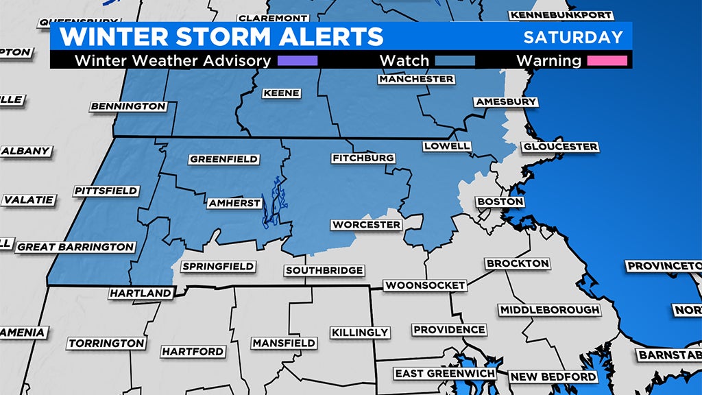
This brings us to this weekend. This has been a tough one to pin down. Over the last week or so, models have gone from nothing at all, to a warm and windy rainstorm to a wintry nor'easter and back again. Currently, as of this writing, less than 48 hours from the peak of the storm, we still have a wide range of solutions…not ideal.
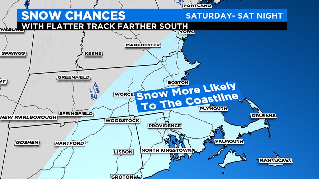
You may have seen some social media posts in the last 24-48 hours showing direct model output of loads of snow in central and eastern MA. While this cannot be ruled out, it is quite unlikely (always dangerous to post any model online without some sort of explainer, you won't see our team do it). There are a few really big factors working against a major snowstorm inside of 495 this weekend. First, the ocean is still quite warm, ranging from 45-50 degrees, significantly above average for this time of year. So, any wind off the water (which of course applies in a nor'easter) is going to flood the shoreline with mild air.
Also, there really isn't any significant source of cold air around. Most times, in order to get a big snowstorm in our area, you need a high-pressure area to our north to pump the cold, Canadian air southward. That simply does not exist this go-around, therefore the storm will need to produce its own cold air, pulling it down from upper levels of the atmosphere. Possible? Yes. Likely? Meh.
So clearly the odds are stacked against us in eastern Massachusetts...not saying it is impossible, but simply saying we would need a lot to go down for any sort of significant snow to accumulate close to I-95 and the Coastline.
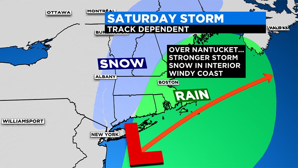
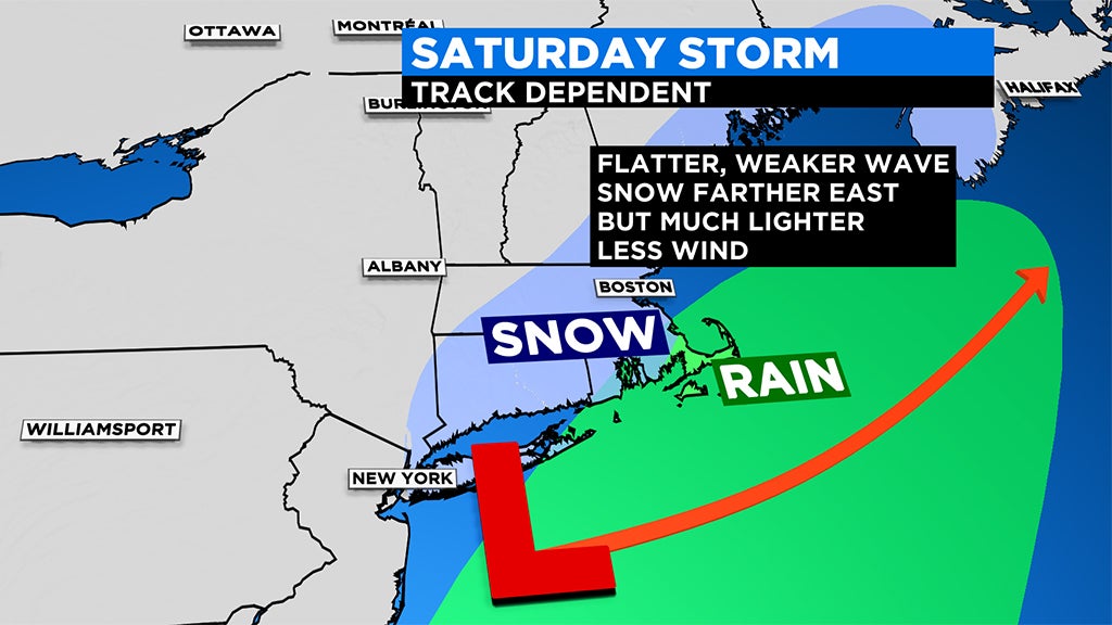
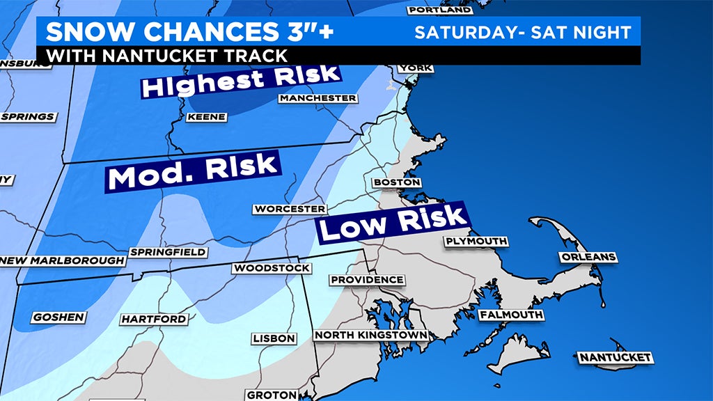
Farther to the north and west, especially in elevated areas, the story is quite different. With a track close enough to the Coastline, we could see significant snow accumulation here. But again, this all depends on the eventual track and intensity of the storm. A weaker storm with a track farther south, could mean nearly nothing well to the northwest of Boston.
Simple right? Ha!
Let's get down to the nitty gritty as best we can…
TIMELINE:
Some rain showers arrive Friday afternoon and evening, not all that heavy. Showers continue off and on Friday night into Saturday morning.
Between 7am and Noon on Saturday, the storm starts to deepen south of Long Island and the precipitation should begin to fill in and increase in intensity.
If there is to be a "peak" of this storm, it will come Saturday afternoon and evening. This is clearly the timeframe to watch. With the right storm track and intensity, we would see heavy, wet snow falling in most of central and western MA Saturday PM. The rain/snow line would likely collapse to the east to some degree later in the afternoon, changing the rain to a wet, pasty snow closer to 495.
A map that I am sure is going to change tomorrow, but gotta start somewhere. Pretty fluid situation with this storm but we'll keep you updated on Friday. #wbz pic.twitter.com/FmDxn0pale
— Eric Fisher (@ericfisher) December 4, 2020
Saturday night, the storm starts to pull away from our area and if there is any precipitation left, it would be turning cold enough for it to all change to snow. Tough at this point to say whether there will be enough juice left for any significant or plowable snowfall at the tail end inside of 495, but it is certainly possible. Either way, temperatures will drop below freezing overnight, allowing for icy areas and slippery travel by Sunday morning.
HOW MUCH:
TBD! Just too much variability in the models right now to pin down numbers and zones. Needless to say, with a track close to Cape Cod, the farther northwest you travel, the more accumulation you would see, perhaps 6" or more in the elevated areas of Western MA, Vermont and New Hampshire. But again, this is highly speculative with such a large room for error given the current data.
WINDS:
Worst case scenario for winds would occur with a stronger storm tracking close to the Cape…under this scenario the north-northeast winds would crank up Saturday afternoon and evening. The entire MA coastline would see gusts 35-55mph. If the storm passes over Cape Cod, the strongest winds would be from Plymouth northward through the North Shore and coastal New Hampshire and Maine. Inland, winds will be less, gusting out of the north-northeast between 15-35mph.
COASTAL FLOODING:
Tides will be astronomically low, so not expecting any significant coastal flooding issues. High tides occur around 2pm Saturday afternoon and 3am Sunday morning, slightly before and after the peak of the winds.
As always, we urge that you stay tuned to updates before and during the storm on WBZ-TV, CBSBoston.com and CBSN Boston…we've got you covered!