What To Expect For The First Winter Storm Of The Season
BOSTON (CBS) -- Warmest December on record. Most 50 degree days every recorded in December. Record shattering 69 degrees on Christmas Eve.
The records continue to pile up in a month that is averaging close to 12 degrees above average per day. This, after a top 10 warmest November and Fall season. Let me re-introduce you to a little 4-letter word that we haven't had to use in a while...S-N-O-W.
The last measurable snow in Boston came way back on March 28th. Not like we're counting but that's 274 days ago.
We've gone more than 39 weeks and over 6,500 hours without shoveling, measuring or driving in the white stuff.
Like an old high school sweetheart who you spent so many days and nights with, we are about to be re-united for the first time since that long, epic winter.
Let me reassure you, this is NOT going to be a major storm. It is NOT a blizzard, not even a nor'easter. There will be no significant winds and no coastal flooding issues. The only real hazard with this storm will be a 6-12 hour thump of snow and ice on Tuesday morning.
It comes at a pretty decent time all things considered. Most schools are out for Holiday break so traffic should be fairly light. Just one commute, the Tuesday AM drive, will be messy. A nice way to ease our way back into the challenges of winter diving and snow removal.
Let's break this storm down:
TIMELINE:
This will start as all snow.
Approximate arrival times:
Midnight: Worcester, Fitchburg, Providence
2-3 AM: Boston, Eastern and Coastal MA
All of the snow accumulation will occur in the beginning of this event, most between Midnight and 7 AM.
By 6-7 AM, warmer air will be flooding in and changing the snow over to sleet from Boston down the Mass Pike to Worcester. In southeastern MA and in many South Shore Coastal towns, the snow will flip directly from snow to rain. The snow will be hanging on at this hour in Essex county, northern Worcester/Middlesex counties and in Southern New Hampshire.
Between 7 am and Noon, the milder air (and rain line) will continue to make progress to the north and west. By Noon, it will be plain rain inside of 495 and all areas from Boston to Worcester southward. Towns outside of 495, including those in northern Worcester County and Southern New Hampshire will remain in a wintry mix, transitioning to a sleet/freezing rain mix.
Finally, during Tuesday afternoon, all of Southern New England will warm above 32 degrees and change the wintry mix to all rain. The precipitation will also begin to taper off from west to east in the afternoon and likely be shut off completely by the PM commute.
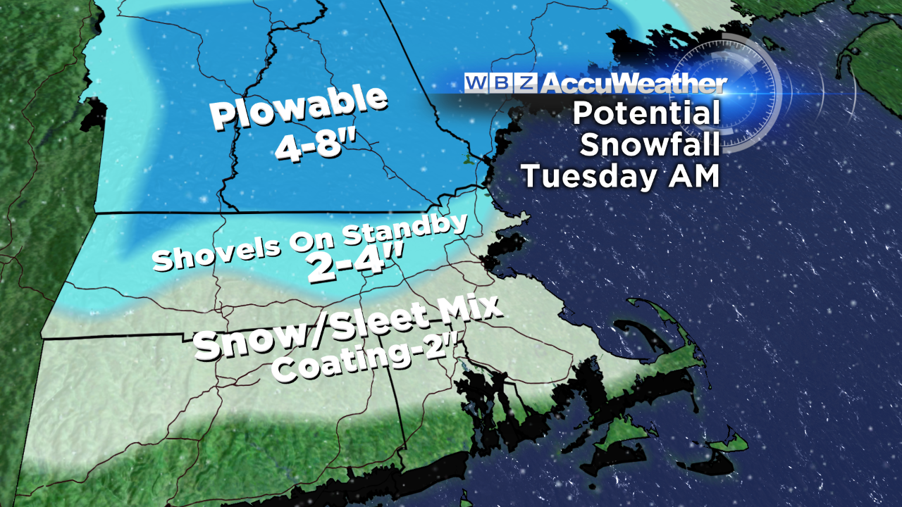
HOW MUCH?
This is a tough call for several reasons: the snow may have a tough time sticking in some spots due to an unfrozen ground and generally warm pavement. Also, any snow that does fall, will be severely compacted by a layer of ice (mainly sleet) and then rain. So, in the end, the totals listed below may look like a lot less.
Providence to Plymouth and points south including Cape Cod and Islands will likely coat to a sloppy inch.
North of a line from Providence to Plymouth, up to the Mass Pike and inside 495 may likely get 1-2", again, wet and sloppy. This includes Boston and Worcester. It is possible that right at Logan Airport, where the official measurement is taken, totals may not even reach an inch (being right on the water), while downtown Boston has a better chance of getting an inch or two.
2-4", wet and crusty: All areas north and west of 495 from Marlboro to Amesbury...this includes northern Essex county, northern Middlesex and northern Worcester counties and extreme southeast NH.
4-8", the "jackpot": Exactly where we need it most, Central and Northern New England (ski country)...also including SW New Hampshire (Monadnock region).
FEW FINAL THOUGHTS
This is truly all about timing. While final snow and ice totals will be fairly low, traveling Tuesday morning will be treacherous in many areas. We're not expecting icing to be a major issue. More sleet than freezing rain, meaning not a whole lot of ice accretion.
It's gonna get cold for a while. Temperatures are forecast to be near or even slightly below average as we head into January. No big snows in the forecast for now, but it will certainly feel more like winter in the next 1-2 weeks.
Stay with the WBZ weather team for updates through Tuesday!
Follow Terry on Twitter @TerryWBZ