Weather experts on La Nina, El Nino and what to expect this spring and summer

HOBOKEN, N.J. - Tuesday was the first full day of spring, and it certainly felt like it.
But after a nearly snowless and mild winter, what will spring and summer be like?
Buds are ready to burst, and some daffodils already did.
Central Park's lawns have been aerated and seeded, awaiting reopening this season.
Unfiltered spring sunshine illuminated the skyline and had the Hudson sparkling like diamonds from a vantagepoint in Hoboken. The sunshine warms the earth, elevates rides and moods.
"I'm loving it. Bring on the sunshine. It always makes me feel better," said Bayonne resident John Kadian.
"It's beautiful. It feels like the first day of spring," said Vashayna Williams of Hoboken. "Spring, for me, symbolizes joy and new beginnings."
Tuesday's first full day of spring follows the winter that wasn't. In fact, for now, we hold the title "least snowy winter on record."
"I am sad in theory that it does not resemble the winter of my childhood, but I genuinely don't really like the snow," said Jersey City resident Georgia Sebesky.
"I'm really excited for what the warm weather has to offer," Williams said.
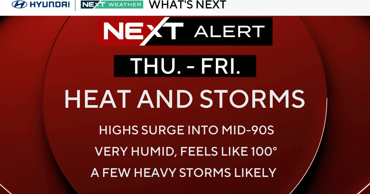
How warm are we talking? Summer warmth? To explore what the second "s" season might bring, we spoke with two scientists: Brian Colle of Stony Brook University and Andrew Kruczkiewicz of Columbia University.
"When we talk about summer in the Tri-Atate Area, we talk about heat, the risk of heat waves, humid conditions and the risk of severe weather," Kruczkiewicz said.
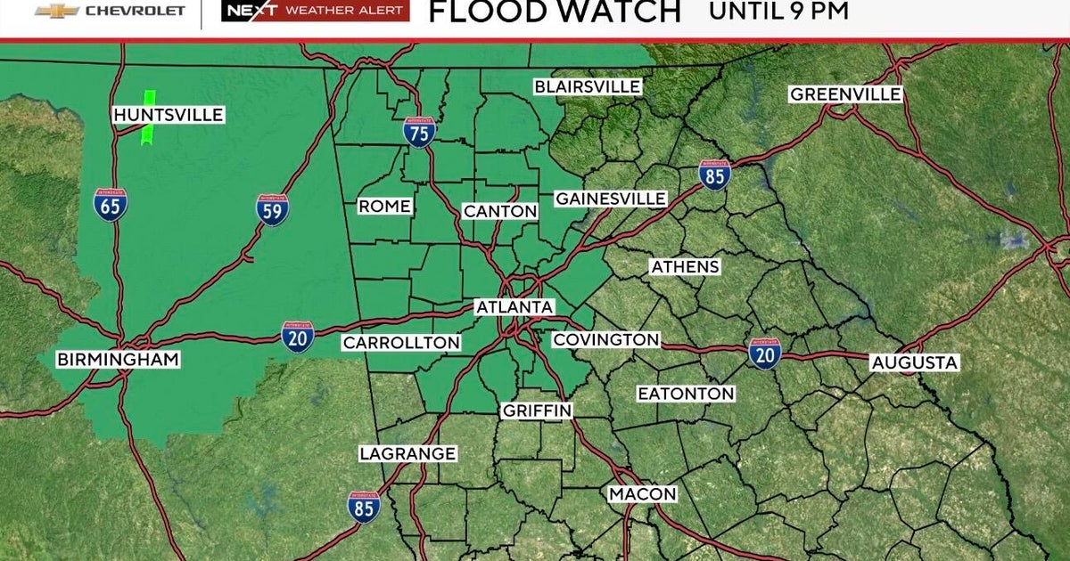
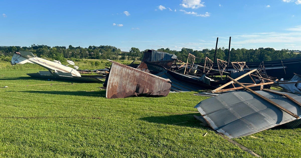
That includes flash flooding and hurricanes. A lot can happen in summer, so let's hone in on heat.
"We've had La Nina for the past two to three years, and that has come to a fairly abrupt end in the past few weeks," Kruczkiewicz said.
La Nina is the cold phase of the El Nino southern oscillation, a Pacific Ocean pattern which affects weather globally and can impact temperatures locally. Colle says models favor a shift toward El Nino heading into summer.
"El Nino in general gives the whole globe somewhat warmer temperatures," Colle said.
Thus, the baseline starts higher.
"If we have El Nino, we have suppressed hurricane activity heading into August, which means less rainfall, and the ground is drier and it heats up more," Colle said.
The other player, locally, is water temperatures.
"Given our warmer than normal winter are already two or three degrees fahrenheit warmer," Colle said.
Colle says the odds favor a warmer than normal summer.
As for precipitation, typically summer delivers hit or miss showers and storms. That is, until a hurricane sets it sights on the Tri-State Area. As Colle shared, El Nino tends to reduce tropical activity, but it only takes one to leave an unforgettable mark.
Kruczkiewicz and Murdock also discussed the importance of wind direction. Typically, serious summer heat gets driven in by winds out of the south and southwest. However, if we get stuck in a persistent easterly wind pattern, temperatures along the coast can stay well below average for days along the coast with very little sunshine. This would be short term prediction, not a seasonal one.