Can we get better at predicting tornadoes?
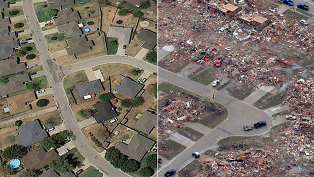
The devastating tornado that hit Moore, Okla., on Monday afternoon did not arrive unannounced. The National Weather Service put out a tornado warning 16 minutes before the tornado touched down, and Rick Smith of the NWS posted a briefing on YouTube more that three hours earlier stating that tornadoes were likely in the area. Based on modeling and historical trends, the NWS had been warning for days that conditions were ripe for a tornado to hit the region.
"The story is not that this was not warned for," said Dr. Marshall Shepherd, president of the American Meteorological Society. "We knew that this area was going to be under the gun."
But the warnings were not enough for many residents of Moore. This is an area that has grown used to the threat posed by tornadoes, and generalized warnings of a possible hit did not prompt officials to get schoolchildren to a safe place or convince most families to retreat to storm shelters for the day. By the time a specific warning came, 16 minutes before the storm touched down, it was too late for many residents to make it to safety.
America is home to the best tornado forecasting in the world, in part because it is home to some of the most severe thunderstorms in the world. (Moore has been hit by tornadoes four times in the past 15 years, which helps explain why the National Severe Storms Laboratory is just down the road from the site of the devastation.) Forecasters have managed to increase the average lead-time for a tornado warning from 5 minutes in the 1980s to about 13 minutes today. (The lead-time is actually closer to 18 minutes when officials put out a warning - but they only manage to do so about 80 percent of the time.)
"This is the hardest forecasting problem of all," said Cliff Mass, an atmospheric sciences professor at the University of Washington. He believes that it is possible to increase the advance time for a tornado warning to as much as three hours, though he doesn't know if meteorologists can do better than that. "I think six hours or eight hours is going to be very hard," he said.
To understand how tornado forecasting works, you have to start by differentiating between (1) radar systems and (2) computer modeling. The United States uses technologically advanced radar systems that allow meteorologists to see when tornadoes are about to form, and the systems are only getting better. Meteorologists are now able to look in great detail at "debris balls" and air rotation to know if a tornado is forming in the short term, which is how they've been able to tick up the warning time over the last few decades. (Even this is an inexact science: The Moore tornado did not touch down where storm chasers expected.)
To formulate longer-term warnings, meteorologists would need to use sophisticated computers to predict what is likely to happen with the weather. And the United States has fallen behind on that front. Last year, the NWS' Global Forecast System was criticized for being less advanced than the European forecasting system, which was able to predict the path of Superstorm Sandy more quickly than the U.S. model.
That situation will change soon, thanks to $23.7 million in funding tied to Sandy relief legislation that will allow for key upgrades to the two National Weather Service computers that form the basis for most weather forecasts. "By 2015, we will be on pace to equal or surpass the European model," said Shepherd.
Mass says that's a good start, though he believes it's not enough of an investment. "They need at least 10 to 100 times more [computing power] than they're getting," he said. Still, he acknowledged, the upgrade (along with advances in data collection) will allow meteorologists to run far more sophisticated weather simulations. That could eventually allow them to improve warning times.
- Will tornado relief funding escape politics?
- No more bodies or survivors likely in the rubble, Oklahoma official says
- Watch: Poignant images capture tornado's emotional aftermath
Complicating matters are cuts to the NWS tied to the sequester and other budgetary decisions. Shepard said there is "a danger right now of plateau" in tornado warning time due to a "very constrained budget environment" at NWS that may lead to furloughs. The NWS is currently under a hiring freeze, and many offices are not fully staffed.
A Department of Commerce spokesperson told the Washington Post in February that as a result of the sequester, "the government runs the risk of significantly increasing forecast error, and the government's ability to warn Americans across the country about high impact weather events, such as hurricanes and tornadoes, will be compromised."
The Government Accountability Office, meanwhile, is warning that satellite data could be compromised for up to 53 months thanks to challenges in replacing failing satellite systems. National Oceanic and Atmospheric Administration officials are warning that the situation may lead to "less accurate and timely weather forecasts and warnings of extreme events."
And then there's this: Because warnings based on computer models will "always be probabilistic," as Harold Brooks of the National Severe Storms Laboratory points out, it may not make sense to use computer modeling to warn the public that a tornado is coming. That's because if they get a specific warning and the tornado doesn't come, people may simply ignore the warning the next time.
Greg Carbin of the National Weather Service Storm Prediction Center told Scientific American in 2011 that there are simply too many variables to confidently make longer-term predictions. While improved data collection and computing power improve the odds of being right, Shepard said he is "not sure a model will ever be able to spin out a tornado" with anything approaching certainty.
According to Brooks, longer-term warnings may be useful "for emergency managers and people who have really sensitive populations like nursing homes." But, he said, such warnings may be counterproductive for everyone else. "We don't know what the ideal lead time is for these kinds of events," he said.
In addition to further upgrading computer systems, Mass believes the NWS needs to invest in more social scientists who will help in "describing threats and motivating people" when a tornado is coming. ("The cry wolf problem," he said, "is very real.") Mass also called for a "national commitment" to build more storm shelters in high-risk areas. While some buildings in Moore had storm shelters for residents to retreat to during the storm, many homes, public buildings and businesses did not.
"Even if the predictions were perfect," he said, "there's still the issue of having safe places for people to go."
FULL COVERAGE: The Oklahoma Tornado Disaster

